AAE faculty profile series: James Garrison

James Garrison couldn’t stop looking up.
As a kid, he was fascinated by the twin spacecraft Voyager 1 and Voyager 2 missions, reading all about how they traveled to the outer planets and returned data and images. He pored over pages about how all that worked, how information was gleaned from such a far distance.
In high school, he built telescopes and looked at different astronomical objects, looked at the planets. He learned all he could about astronomy, filling his mind with details of moons, stars and galaxies.
His interest was fueled by one high school teacher, specifically, who provided unique perspective. The teacher, who had completed coursework but never finished a thesis for a Ph.D. from MIT, stressed how science is a process. Garrison’s curiosity intensified. He wanted to understand how were details learned about the outer planets, about space? What was the logical process for how to put all those things together and learn those things?
Around the same time, Carl Sagan’s 13-part TV series “Cosmos: A Personal Voyage” was airing, and Garrison's mind churned with more questions about the “how.”
How did people know what the atmosphere of Mars is like?
How did Einstein conceive of the theory of relativity? How was it demonstrated?
His interests evolved into how progress in science, engineering and inventions were driven or influenced by historical context. Learning about the history of astronomy, he became interested in the development of the scientific method during the Enlightenment and the broad effect that had during that and subsequent periods. Later, as an undergraduate at Rensselaer Polytechnic Institute, he took elective courses in the Philosophy of Science.
“Throughout my career, I’ve always had interest in the connection, the interplay between technology and science and how they influenced the broader society,” Garrison said. “That’s always been a theme throughout my career.”
Forty years later, Garrison still is looking up and wondering. Albeit with a considerably heftier knowledge base. And with an emphasis on broader impacts.
Now, as a professor in the Purdue University School of Aeronautics and Astronautics, Garrison sees new approaches to Earth remote sensing that he’s developing sparking new research from space.
He has pioneered the application of reflectometry methods beyond Global Navigation Satellite Systems (GNSS) to the general class of “signals of opportunity” (SoOp) to enable new remote sensing capabilities in oceanography, agriculture and hydrology.
SoOp is emerging as an alternative third way of microwave remote sensing, complementing well-established active (radar) and passive (radiometric) methods.
“I think there is some of both the thrill of the journey and the goal of the destination in Jim’s work,” said University of Michigan Professor Chris Ruf, who started working with Garrison in 2011. “The journey is the day-to-day work of designing, debugging and operating new remote sensing methods. I think he really enjoys those challenges. The goal is helping to answer the most pressing questions of our time about the Earth system and regional and global climate change. I think those questions motivate much of his work.”
Piquing interest
In the early 1990s, there was a big push to grow Earth observation capabilities, and NASA’s Langley Research Center was looking at studies of new missions, new concepts, constellations and new instruments.
One of the things Langley was being asked to study was oceanography missions, which presented very challenging requirements to determine satellite orbits with accuracies at the centimeter level. At Langley, Garrison met senior engineer Steve Katzberg. Katzberg came from an optical remote sensing background — he worked on the Viking spacecraft cameras and optical sensors. They clicked.
At the time, there was a lot of discussion about a “new thing” called the Global Positioning System, which was first developed as a military navigation system but later made openly available for civilian and scientific use.
Because Garrison had some background in orbital mechanics, he was asked to investigate.
“That got my interest going. It was on the border between the engineering and the science,” said Garrison, who did a couple Co-Ops at Langley during his undergrad at RPI. He completed a master’s degree at Stanford but was not admitted to its Ph.D. program, a setback that turned out to be fortuitous.
Langley was working with a group at University of Colorado at Boulder.
Garrison had been looking for an opportunity to return to graduate school and pursue a Ph.D., so he applied to Boulder. He came across a new professor, Penina Axelrad, one of the first people who started looking at broader applications of GPS. Garrison became one of her early Ph.D. students. They started looking at different GPS applications for orbit determination.
After Garrison’s Ph.D., Katzberg asked Garrison to explain how the signal processing in GPS worked, among other things. He wondered if they could use the GPS signal as a radar altimeter, which was one of the instruments on science missions that required very high-precision orbits.
They were looking to examine global sea-surface rise, which had traditionally been done by taking radar altimeter measurements over the oceans with very precise orbits so they could go back over the same tracks on subsequent revisits. The requirement on precise repeatability limited the coverage of the ocean’s surface to sparsely separated tracks.
Family
Life partner, Marian
Always makes time for ...
Reading and audiobooks, mostly on philosophy, history or biography. Travel, exploring nature and meditation.
Did you know?
His father, James, worked at Boeing for more than 40 years, mostly at its helicopter division in Philadelphia, which is where he and Jim’s mother, Shirley, met.
“We started thinking and had this idea: Could we use reflections of the GPS signal where we still had the very precise timing and ranging capabilities and, basically for free, we’ll get this radar measurement?” Garrison said. “So we wrote an internal proposal, and it got funded.”
They built an instrument by modifying the software in an early commercial GPS development kit and collected some data on an aircraft flight over the Chesapeake Bay. The data showed they could track the reflected signal and, most importantly, verified that properties of the signal changed in a predictable way, depending on the spectrum of the ocean surface. That validated the theory they could actually make oceanographic measurements by looking at the scattered signal.
“That was the first time I’d worked through something in theory and then actually collected the data and showed that it worked. So that was an important moment,” Garrison said. “Everything up to that point had just been theory.
“We thought it was a really interesting thing. We published it in 1998. It’s still my second-highest cited paper.”
The Earth science community acknowledged the work as a neat novelty but questioned the application.
“It took a long time for me to really understand what the applications would be and see some broader applications of that work,” Garrison said. “It was kind of an alternate to the existing remote sensing techniques.”
Garrison left Langley in 1998 and started at NASA Goddard Space Flight Center. There he led some projects looking at new-at-the-time techniques for using GPS in high-altitude orbits, very elliptical orbits, integrating the orbit dynamics with the signal processing inside the receiver.
But the real breakthrough was yet to come.
Finding a fit
Eric Lindstrom had a mission.
During his 20 years as a program manager at NASA headquarters, he selected a couple of young scientists each year who might need help getting their first funding or a leg up. There were a couple technological innovations Lindstrom knew he wanted to target, telemetry remote sensing from space and the “free signal” from the GPS satellites.
Soon after joining NASA in 1997, Lindstrom ran into a couple of guys at Langley. Garrison was working with Katzberg on studying GPS reflection.
Garrison was exactly what Lindstrom was looking for.
“I found Jim Garrison to be very earnest and smart and all those properties you like,” said Lindstrom, who had more autonomy in those days before the era of program solicitations. “I knew if he got some support initially that he’d be good for a lifetime of research. The value was there.
“I always looked for smart, dedicated people. You can't just have a problem and give it to anybody. You want somebody who is going to be persistent. That’s been proven true.”
Lindstrom initially facilitated a three-year funded project for Garrison’s work in the early 2000s, he said.
Academia turn
Though Garrison enjoyed the work for NASA, he wanted to start developing his own ideas and leading his own work. So, he turned to academia.
As he was actively looking for a faculty position, he learned Purdue was looking for someone to “take the department in a different direction.” He started on the AAE faculty in 2000.
“It kind of just came together,” Garrison said. “I’m motivated on the research side. That’s the main attraction. But I also liked the idea of being able to mentor graduate students who have similar interests as I do. I kind of work in an interdisciplinary area, so I wanted to start educating graduate students who had more of a multi-disciplinary background.”
In the first 10 years or so at Purdue, Garrison published papers and gained some interest but still was trying to get support for a space mission to demonstrate what is now called reflectometry. Garrison’s group had developed a few science cases for it and a few new measurements they could make.
And then, in 2010, two things happened that launched the next stage of his career.
For one, software-defined radio capabilities came out. One company started selling a low-cost development kit that one could program to record a wide range of radio frequencies. Previously, the analog portion of a receiver had to be a custom design for one specific frequency and signal, requiring extensive microwave circuit design knowledge to do it right.
The ability to capture most any microwave signal and perform a variety of signal processing operations, entirely in software, opened up the possibility to study many other signals, especially those transmitted from communications satellites.
“We did some early (airborne) experiments of the Chesapeake Bay, paid for a number of flights to collect reflected signals from a communication satellite,” Garrison said. “We showed we can make a very similar measurement as was done with GNSS but at a higher frequency and at a much higher signal to noise ratio using this communication satellite.”
The second major development in 2010: A phone call from Chris Ruf.
Breakthrough mission
Garrison was not optimistic.
And he told Ruf as much, when Ruf reached out to propose a big mission.
Garrison regaled his colleague with the whole history of previous proposals he had submitted to get support for a space mission to demonstrate reflectometry technique that weren’t successful.
Ruf, a well-known expert in microwave radiometry at the University of Michigan, knew NASA preferred to select major proposals led by investigators with significant prior experience working on other NASA science missions. Ruf had worked on a number of those. He needed a collaborator who had experience with the specific measurement technique being proposed: That was Garrison.
The goal was to track tropical storms using Garrison’s technique of ocean remote sensing using satellite navigation signals.
“Jim was one of the originators of the remote sensing technique on which the mission is based, namely radar reflections using GPS satellites as transmitters,” Ruf said.
For the proposal, Ruf’s group mostly came up with a science case. By using the reflected signals and not having to provide their own transmitter, the team could make a very small instrument. So instead of one satellite, their mission had a constellation of eight small satellites, which would provide much denser coverage of the Earth to observe tropical cyclone development.
They submitted the proposal, called Cyclone Global Navigation Satellite System (CYGNSS), to an open NASA solicitation.
It was selected.
“That really surprised me,” Garrison said. “I didn’t think it had any chance at all.”
The team worked with meteorologists and looked at the development of hurricanes where, historically, they’d had good forecasts and some not-as-successful forecasts. One of the issues was a period of rapid intensification that happens in only a few hours. Radar satellites in orbit repeated about once a day. Even incorporating satellites operated by other nations, there’d still be measurements only twice a day.
CYGNSS changed that.
It had a short revisit of between one-and-a-half and eight hours during periods of rapid storm intensification and used frequencies that can penetrate heavy rain, providing a much denser sampling.
Garrison’s primary role in CYGNSS was developing a lot of the research algorithms. He looked at how to take a new measurement that didn’t have the same statistics or the same error models as traditional radar measurements and worked to incorporated them into forecast models. That required understanding of statistics, measurements and modeling. In the latter area, Garrison has done a lot of work collaborating with the National Oceanic and Atmospheric Administration (NOAA) and its contractors.
CYGNSS has been producing ocean surface wind retrievals since shortly after its launch in 2016. NASA extended the mission to 2023.
“We’ve shown some really good results and different ways of processing the data and have a little deeper understanding of what’s in the data,” Garrison said.
The data is publicly distributed to the global science and weather forecast community with a growing community of end users applying the data to a wide variety of applications beyond tropical cyclones.
CYGNSS has demonstrated the scientific value of the GPS-based radar technique with its measurements of ocean winds in a hurricane, measurements of flood inundation after landfall and a number of other new types of remote sensing.
“I think it is safe to stay that, more than any other single individual, CYGNSS would not have come about without Jim’s early seminal work in GPS-based bistatic radar remote sensing,” Ruf said.
“Jim is an extremely creative research engineer. He is always pushing the boundaries in his work, whether it be with new technologies or new scientific applications of the measurements.”
Making history
With the advent of software-defined radio and the capability of using a broader variety of sources, Garrison recognized the true promise of SoOp.
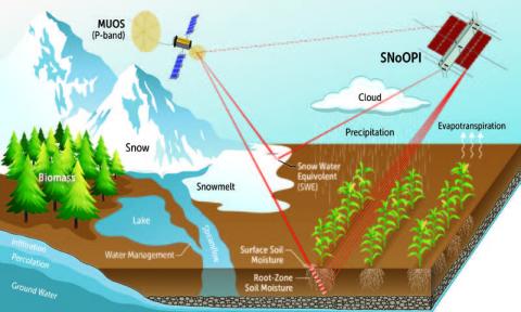
Low frequencies, in particular, are needed to penetrate dense vegetation and soil in order to sense root-zone soil moisture (RZSM), a critical variable for understanding the water cycle. It isn’t currently feasible to measure RZSM globally from orbit because that would require an antenna about 30 meters in diameter and would encounter substantial interference from terrestrial and spaceborne communications.
Garrison’s group came up with the idea of capturing lower frequency “P-band” signals from telecommunications satellites. By using P-band, which can penetrate through vegetation and deeper into the ground, they could make the subsurface soil measurement.
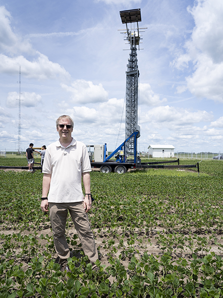
After getting funding, Garrison developed an airborne instrument prototype to extract soil reflectivity from specific communication satellite transmissions and used it to conduct a series of field experiments. Following success of those experiments, NASA selected Garrison’s proposal for a spaceborne demonstration of Signals of Opportunity: P-band Investigation (SNOOPI) in 2018.
It was the first NASA science mission managed by a Purdue principal investigator.
SNOOPI will operate differently than other radar remote sensing missions. Instead of generating and transmitting its own radio signals toward Earth and analyzing the returned signal, it will take advantage of already-available telecommunications signals.
Garrison is working with a group at NASA’s Jet Propulsion Laboratory, led by his former Ph.D. student Rashmi Shah, on the project. JPL is interested in measuring water contained in snow in addition to the root-zone soil moisture. The mission has an expected launch date of early 2022.
“Those are two of the measurements that we can’t currently make globally that are needed in a large number of applications from weather forecast to drought and flood forecast and different applications like that,” said Garrison, who has begun a collaboration with Purdue's College of Agriculture, recognizing the potential value of the measurements to that field.
Building relationships
Sharing all of that real-world mission experience with AAE students has been vitally important for Garrison.
When he teaches AAE450, Spacecraft Design, he goes through how a real mission proposal is put together and talks about risk assessment, cost modeling and part selection. Those are things that can be the difference between success and not success, he said.
Students say they appreciate that perspective.
Alinda Mashiku, who had Garrison has a Ph.D. advisor, called it “one of his biggest fortes.”
“He encouraged us to think beyond just the research component of our work,” Mashiku said. “Not everybody is going to be a professor once you get your Ph.D., so it was more toward thinking about how your research ends up affecting the real world that happens in industry. The product of your work does not end with a patent, a research paper or a journal article. The real impact of the algorithms and capabilities can end up flying in space.”
Because of Garrison’s experience gained during stints with NASA Goddard and Langley or in the subsequent NASA partnerships, he also understands relevant industry problems. He can work to assess challenges now that may present themselves in the next 10 years. That perspective should guide what type of research one is looking to start, Garrison said.
With that in mind, he has developed several new courses while in AAE — Intro to Satellite Navigation and Positioning (AAE575), Advanced Signals and Systems for Satellite Navigation (AAE675), Intro to Remote Sensing (AAE523) and Remote Sensing System Design (AAE590).
He also has brought in speakers from various NASA centers, further amplifying the practical application of materials students were learning.
The new courses were sparked from his interests, of course, but also with a motivation to have students ultimately prepared for the evolving industry. That’s also why, though not technically a requirement of being one of his graduate students, they always seem to wind up with internships. Most have been at NASA centers, but his students also have had internships at institutions as diverse as the Royal Netherlands Meteorological Institute and Starlab, a small private company in Barcelona, Spain.
For Rashmi Shah, Garrison walked in to the lab, told her about an opportunity at Goddard and asked if she’d be interested.
“Of course, I jumped on the offer, but I didn’t even realize that was possible until then,” said Shah, who was a student of Garrison’s for seven years.
For Mashiku, multiple summers were spent at Goddard, after Garrison helped her meet up with a person he worked with there who became an advisor for her NASA-funded graduate student fellowship.
Working on real missions at Goddard — hearing people not just talking about orbit determination but looking at very unique challenges they were facing on each mission — helped Mashiku think differently about models and algorithms she used in her research at Purdue.
“In physical models and algorithms, we always have assumptions and unknowns. We model or capture them using constants or process noise, respectively. But in real-world missions, when we encounter noise, we try to understand what does that mean? Does it always stay the same? Can it be further understood?” she said. “It’s beyond textbook information, which I think is so crucial.”
Garrison has a similar motivation with his graduate students when they’re on campus. He’s intentional about pushing them to define problems and come up with answers, providing hints along the way but never exactly saying right or wrong. That requires students to dig deeper.
It is more guiding and “letting them go off on their own,” he said.
“He gives individuals enough space to figure things out on their own and succeed while providing ample opportunity to do so,” Shah said. “Oftentimes I would be stuck in things for days, but oftentimes a five-minute conversation with him would be enough to give enough direction to move forward.”
Though that expectation of searching can be difficult in the moment — former students said they sometimes felt like Garrison was questioning what they were saying — ultimately, students look back and see tremendous value.
“At the end of it, you felt like you understood more,” Mashiku said. “For me, I appreciated that because it helped me not just say, ‘Oh, this is the right answer. I’m done. I’m good.’ But ‘Why do you think it’s going to work? What are its limitations? Why do you think that’s applicable for this scenario?’
“It makes you realize you need to know and fully understand what you’re doing so that any research paper you put out, anything that you’re doing at work actually makes sense, not just because, ‘Oh, I got a nice converging result.’ I valued that.”
The questions, the insistence on expert-level knowledge of subject matter, never relents.
Much like the committee Garrison compiles for the defense, he likes to include a faculty member from the sciences, one outside non-faculty member involved in the research from a sponsoring or collaborating organization and an expert in a fundamental area, such as estimation theory or signal processing, relevant to the research. Some professors may help students answers the barrage of questions in that scenario. Garrison, though, uses the circumstance to test students, making sure they have a full grasp on their topic.
“That setup was so instrumental, right now in hindsight,” said Mashiku, who currently serves as deputy manager for the Conjunction Assessment and Risk Analysis (CARA) program at NASA. “At work, we have engineering reviews. We have presentations with management, and when you have questions coming at you from different angles, I idyllically remember my dissertation defense and the several practice sessions I had with Garrison and (Professor Art) Frazho. It was a hot seat that I braved and survived. So at work I tell myself, ‘I’ve been there, done that. Bring it on. So I appreciated that. I still do get nervous, but now I have the muscle to pull through, thanks to the defense committee.”
The relationships rarely end once students graduate.
Garrison doesn’t let them.
In fact, he does what he can to facilitate the next step. That’s certainly not a requirement — for professors to find Ph.D. students a place to work. But Garrison expending energy to find the right connections shows how much he’s invested.
When Shah was about a year from graduation, Garrison put her in touch with someone at JPL. She had a conversation with the contact and, “next thing I knew, I had an offer in my hand.”
“He works very diligently and works with every student to make sure that they succeed,” Shah said. “He takes into consideration students’ personal limitations, where appropriate, and comes up with creative solutions. In other words, he doesn’t give up on students easily.”
Since she’s been at JPL, Shah has worked with Garrison on multiple proposals, and they have continued to collaborate effectively. Shah said the transition from student to colleague has worked “seamlessly.”
After Mashiku started at Goddard, she remembers Garrison checking in to see how things were going, making sure she liked the work and being ready with ideas she could do if she wasn’t satisfied.
“He cares deeply about the work that I do,” she said. “That is true not just for me, that is true for all the students he’s had. He made it personal to him that when you graduated, it was almost his responsibility that you were able to fly. That was pretty neat. He was there to provide that support and he was proactive about it.”
'An inch wide and a mile deep'
Caring deeply always has been a hallmark of Garrison and his work.
He’s always wanted to do more with his career than just earn a paycheck. It’s been about seeking answers, about creating. When he first started, he didn’t know what it was going to be, didn’t know the exact structure it would take. But as soon as he figured it out, he was relentless in his pursuit.
That’s led to incredible accomplishments, many stated in the citation when he was elected Fellow of the Institute of Navigation in 2018:
For contributions in developing and applying GNSS reflectometry methods for space-based and airborne remote sensing of oceanography, agriculture and hydrology; and expanding the methods to other signals-of-opportunity.
His groundbreaking contributions demonstrating that reflections of GNSS signals contain valuable information on surface scattering.
Seminal research that sparked the subsequence development of an entirely new Earth remote sensing instrument concept used to advance research, leading to the competitive selection of the CYGNSS mission.
Ultimately, Garrison’s insatiable curiosity and persistence produced an incredible impact.
“There are a lot of scientists who I would characterize them as big picture. They’re a mile wide and an inch deep,” said Lindstrom, the former NASA program manager. “Jim Garrison is an inch wide and a mile deep. He has been into this particular field for his entire career. That makes for great progress in the field of science when somebody can just focus on this for so long.”
Working with Garrison has taught me how to think critically beyond the results that you’re seeing in front of you.” – Alumna Alinda Mashiku
Professor Garrison is an amazing mentor and advisor. He’s gone above and beyond to ensure my Ph.D. journey is a successful and positive one. His level of caring has humbled me, and I am eternally grateful that I decided to work with him. I returned to grad school after a hiatus in my Ph.D., and he’s worked with my circumstances to make the transition back to research seamless and stress free. He’s never given up on me through the years, and that’s been quite a strength to me. I’m currently in Australia on a Practicum with UNSW, and it was he who made it possible.” – Current Ph.D. student Rozaine Wijekularatne
He prepared us well for the real world. I got a holistic experience writing proposals, designing and planning experiments, data analysis, presenting materials at the conferences, as well as writing papers. The experience had prepared me to succeed in my JPL career." – Alumna Rashmi Shah