Mobile Mapping Systems
Mobile Mapping Systems (MMS) can be defined as moving platforms upon which multiple sensors and measurement systems have been integrated to provide three-dimensional near-continuous positioning of both the platform’s path in space and simultaneously collected geo-spatial data.
Mobile Mapping Systems (MMS) can be defined as moving platforms upon which multiple sensors and measurement systems have been integrated to provide three-dimensional near-continuous positioning of both the platform’s path in space and simultaneously collected geo-spatial data. MMS include systems mounted on satellite, aerial, and terrestrial platforms (Figure 1). The research in this area has been concentrating on the following four groups:
- Calibration of various system components, accuracy analysis, and verification.
- Automatic tracking of linear features in sequential stereo-imagery captured by a terrestrial MMS.
- Automatic recognition of road signs in color terrestrial imagery.
- Integration of aerial imagery and trajectories of terrestrial MMS for orientation and change detection applications.
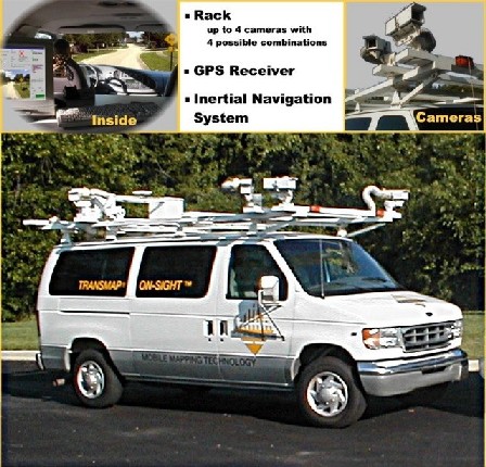
Figure 1: Examples of a Terrestrial Mobile Mapping System
(Courtesy of TransMap Corporation™, Columbus, Ohio, USA