Change Detection
Change detection is the process of identifying differences in land cover over time. As human and natural forces continue to alter the landscape, it is important to develop monitoring methods to assess and quantify these changes. Recent advances in satellite imagery, in terms of improved spatial and temporal resolutions, are allowing for efficient identification of change patterns and prediction of areas of growth. Change detection analysis might involve multi-spectral, multi-source, and/or multi-resolution imagery that have been captured at different times. Accurate co-registration of these datasets is a prerequisite step for a reliable change detection procedure. A new approach for automatic image registration has been introduced using linear features. Derived edges from the registered images are used as the basis for change detection. The utilization of edges is motivated by the fact that they are invariant with respect to possible radiometric differences between the images in question.
Experiments have been conducted using multi-source, multi-resolution, and multi-temporal imageries over the city of Calgary in Alberta to illustrate the feasibility of the suggested methodology. The experiments incorporated an aerial photo captured in 1956 and an ortho-image created from an aerial image captured in 1999. These scenes exhibit significantly different geometric and radiometric properties. Straight-line segments have been manually digitized in these images. Figure 1 shows the digitized segments in the 1999 ortho-photo and 1956 aerial image.
Figure 2-a shows the change image resulting from the registration of the 1956 aerial image with the 1999 ortho-photo. In this image, white areas indicate changes while black areas indicate parts with no change. Simple statistics show that there is roughly 50.6% change between the 1956 and 1999 imagery. The sub-images (b, c, d, and e) in Figure 2 show different types of changes that took place.
Figure 3 shows another example of the change detection image. The experiments incorporated a SPOT image and an IKONOS image.
Experimental Results:
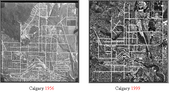
Figure 1. Digitized segments in the Calgary 1999 ortho-photo and 1956 aerial images
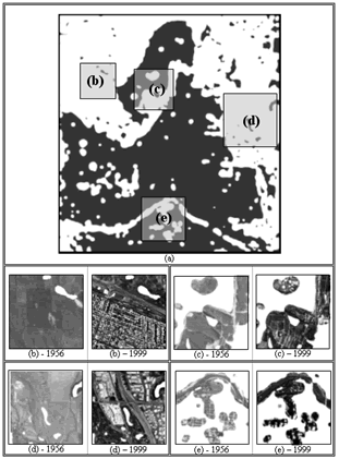
Figure 2. Change detection image (a), white pixels represent changes. Sub-figures b, c, d and e have been cropped and closely examined

Figure 3. Detection changes between IKONOS and SPOT images