Drones and LiDAR surveys reveal alarming changes in Lake Michigan shoreline
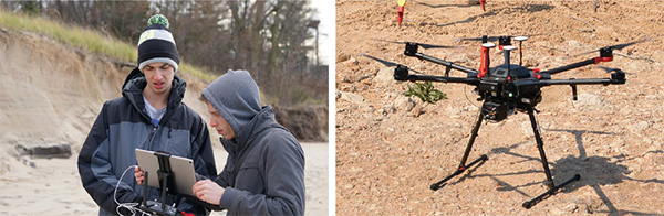
The Purdue research team uses this drone fitted with a LiDAR device to measure coastal erosion at southern Lake Michigan.
Around Lake Michigan, coastal erosion is progressing so rapidly that beachfront properties soon could be located in the lake itself, Purdue Civil Engineering researchers say.
Since May 2018, Cary Troy, associate professor of civil engineering, and Ayman Habib, the Thomas A. Page Professor of Civil Engineering, have been using unmanned aerial vehicles (UAV) equipped with a Light Detection and Ranging (LiDAR) system, along with satellite images, to quantify coastal erosion around Lake Michigan. According to their findings, the lake's water levels are now at near-record highs, and the entire coastline is eroding at a very alarming rate.
"It's getting to the point where portions of beaches have completely washed away," Habib says. "And the erosion is not showing any signs of stopping."
In an effort to monitor the increasing erosion accurately and to keep city managers and affected residents informed, Habib and Troy's research team has set up a monitoring system that makes use of the UAVs equipped with LiDAR.
LiDAR is a remote sensing method that uses pulsed laser light to measure distances. Light pulses from the UAV — combined with trajectory data collected by a global navigation satellite/inertial navigation system — produce 3D point clouds with 2-3 centimeter position accuracy. The point clouds can be used to generate digital surface models, which provide precise descriptions of the Earth's surface. Unlike satellite images and aerial photos, LiDAR provides 3D data that allows researchers to extract transects (a traditional metric of shoreline change) and quantify volume loss.
According to the study's findings, between May 2018 and May 2019, a 220-meter section of southern Lake Michigan showed a loss of 4,000 cubic meters of sand along the shoreline. That is roughly 7,700 metric tons of wet sand lost.
Meghdad Hashemin, PhD student and research team member, says it has been eye-opening to see the erosion progression.
"I didn't expect to see these kinds of changes in just a few months — I don't think anyone did," Hashemin says. "It's amazing to see — and very concerning."
The team has been monitoring multiple areas on the southern coast of Lake Michigan between Gary and Michigan City in Indiana.
"The rapidly rising water levels over the last few years appear to be the main reasons for the erosion," Habib says. "The higher water levels bring wave energy to parts of the shoreline that have not had time to adjust to the new lake levels."
The team is assembling a report for publication, detailing its findings. Habib says the team will publish the report by the end of this year.