Image Registration
Image registration concerns the problem of how to combine data and information from multiple sensors in order to achieve improved accuracy and better inferences about the environment than could be attained through the use of a single sensor. Registration of imagery from multiple sources is essential for a variety of applications in remote sensing, medical diagnosis, computer vision, and pattern recognition. In general, an image registration methodology must deal with four issues. First, a decision has to be made regarding the choice of primitives for the registration procedure. The second issue concerns with establishing the registration transformation function that mathematically relates images to be registered. Then, a similarity measure should be devised to ensure the correspondence of conjugate primitives. Finally, a matching strategy has to be designed and implemented as a controlling framework that utilizes the primitives, the similarity measure, and the transformation function to solve the registration problem.
To illustrate the feasibility and robustness of the suggested registration process, experiments were conducted using a dataset that covers the city of Daegon, Korea. Figure 1 shows sample image patches. These scenes were captured at different times (multi-temporal) and exhibit significantly varying geometric and radiometric properties.
Figure 2 shows the digitized segments in IKONOS and SPOT scenes. Figure 3 depicts the established correspondences between the digitized primitives in the IKONOS and SPOT. The estimated transformation parameters are then used to resample the reference image to the coordinate system associated with the input image. Figure 4 shows a mosaic image derived by combining IKONOS and SPOT scenes (where every other square patch in the reference image has been replaced by the corresponding resampled patch in the input image). Features (e.g. roads, rivers, and buildings) in the derived mosaic accurately fit each other (as seen in the solid circles). However, one can also note that there are some discontinuities along the boundaries between some of the resampled patches (highlighted by dotted circles). These discontinuities are attributed to physical changes in the object space between the epochs of capture of the involved scenes. (The SPOT scene was captured a few years earlier than the IKONOS.)


Figure 1. Scenes with varying geometric and radiometric properties
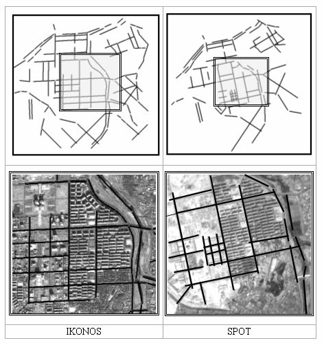
Figure 2. Digitized linear features in IKONOS and SPOT scenes
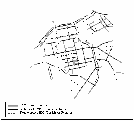
Figure 3. Established correspondences between IKONOS & SPOT primitives
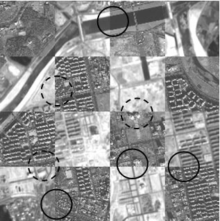
Figure 4. IKONOS-SPOT mosaic with highlighted continuities (solid circles) and highlighted discontinuities (dotted circles) resulting from physical changes in the object space