Mapping the Urban Forest
LiDAR-equipped bike pack collects data to create digital twin of the environment
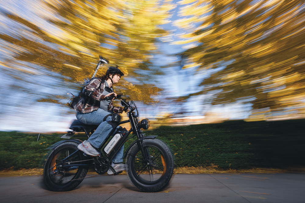
Pedestrians walking around Purdue’s West Lafayette campus gave Colton Gomoll some strange looks as he pedaled by on an e-bike last summer. What those passersby may not have known — Gomoll wasn’t just cycling; he was conducting science.
“If you’re trying not to look goofy, the bike pack system might not be for you,” Gomoll said. “Not only was I wearing a high visibility vest, helmet, knee pads and elbow pads, but there’s also a large antenna sticking up out of the backpack with a LiDAR scanner and an RGB camera attached.”
As he cruised by on the e-bike, the bike pack platform collected LiDAR data that can be used to create a realistic digital representation of the environment. This digital twin enables precise spatial measurements of the landscape, streetscape, buildings and trees.
“Using remote sensing to gather data on the natural and built environment allows for more efficient planning and management of urban forests,” Gomoll said.
Gomoll, a junior civil engineering major from St. Charles, Illinois, was part of a team of undergraduate researchers contributing to a project led by Ayman Habib, the Thomas A. Page Professor of Civil Engineering, and Songlin Fei, the dean’s chair of remote sensing in the Department of Forestry and Natural Resources and founder of ArborMapper. Fei is also the director of Purdue’s Institute for Digital Forestry and Habib serves as the institute’s associate director.
“For this project, our primary focus was using LiDAR data collection to conduct an inventory of urban trees and infrastructure,” Habib said. “This information is useful in monitoring the health and growth of trees. Understanding the relationship between buildings and trees plays an important role in reducing the heat island effect in urban environments. At the same time, we can gather information about the condition of infrastructure, such as sidewalks, and generate an as-built model of the environment.”
The researchers are not only collecting data but processing it to provide information to end users. In previous Li-DAR studies, Habib’s team has provided information on infrastructure to transportation departments; mapped coastlines to evaluate the impact of water levels; and monitored agricultural fields for seed breeders and farmers.
In this current project, Habib aims to create a complete digital twin of Purdue’s West Lafayette campus. Such a model can be used by architects to evaluate the condition of the buildings, arborists to monitor tree health and grounds crews to assess safety of sidewalks — by identifying both places of deterioration and areas in need of more lighting.
“It’s a single data collection with multiuse value,” Habib said. “The payload we’ve designed can be mounted on several systems — an individual walking or riding a bicycle. It can also be mounted on crewed or uncrewed ground and aerial vehicles.”
Purdue has plans to commercialize the technology which will make data acquisition faster, cheaper and more accurate. One of the goals for the Institute of Digital Forestry is to map every tree on the planet, and the LiDAR data collection and processing system developed by Habib’s research team could help achieve that goal.
“Right now, metrics related to carbon credits or estimated timber production are not based on precise measurements,” Habib said. “It is very easy to excessively overestimate or underestimate the amount of greenhouse gas emissions being reduced or potential board feet for harvesting. Using this technology to obtain accurate measurements of every tree in the forest could have huge economic value.”
Involving undergraduates in the project gives students an opportunity to put theory into practice and to contribute to interdisciplinary research.
“Purdue is known for its expertise in engineering and agriculture and there is strong collaboration between the two colleges,” Habib says. “I consider myself privileged to work with individuals in diverse fields.”