Engineering 3D City Models
Date will inform urban planning, disaster mitigation
Purdue researchers are using images taken from space to recreate picture-perfect 3-D models of cities.
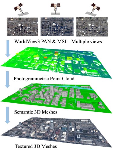
Through the collection of spaceborne, airborne and terrestrial images, Lyles School of Civil Engineering faculty and students have developed the capability to produce large-scale city models using 3D point clouds. These models are geometrically accurate, topologically consistent, physically genuine and computationally portable.
“These 3D models provide an incredible amount of information on a city that we can review on a computer unlike ever before,” said Jie Shan, Professor of Civil Engineering with a courtesy appointment in the Department of Earth, Atmospheric and Planetary Sciences. “They provide necessary information for situational awareness, 3D navigation, disaster mitigation, energy management and sustainable development.”
The models will also serve as crucial foundation data for digital twin development and smart city management. The final products can be visualized and utilized in a variety of design software packages, social media and meta reality across different platforms.
Researcher and civil engineering PhD student Zhixin Li said both urban development and disaster response would benefit from this work. It will greatly aid city planners and emergency responders.
“The highly-detailed and accurate data that this program can provide will help anyone working for the city,” Li said. “When it comes to development, improvement or disaster response, the more detailed and accurate information you have, the better you can do your job.”
Shan added, “What we have already been able to accomplish and visualize has been incredible. Besides major projects like development and city safety, this program could also be used for simple improvements and urban planning such as locating the best places to install solar panels.”
Collaborating in this research are Kitware Inc., Raytheon, Columbia University and Rutgers University under the support of the Intelligence Advanced Research Projects Activity (IARPA).