![]()
![]()
![]()
![]()
Watershed Protection
Because so much is currently being written about watershed protection and related topics, we have developed an Inventory of educational material for watershed protection including links to most Web-accessible sources.
Watershed Protection and Indiana's Drinking Water
 Community
water systems that use surface water can benefit by developing a
watershed protection plan to protect their water supply from current
and future contamination. To help communities start developing
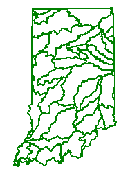
watershed protection plans, we have developed maps
of all Indiana public water supply watersheds (except those that
use Lake Michigan or the Ohio River).
Community
water systems that use surface water can benefit by developing a
watershed protection plan to protect their water supply from current
and future contamination. To help communities start developing
watershed protection plans, we have developed maps
of all Indiana public water supply watersheds (except those that
use Lake Michigan or the Ohio River). From these watershed maps we use GIS-based information to calculate watershed size and land use for each water supply system.
Watershed Protection and E. coli
E.coli is a concern in many Indiana lakes and streams. Concerns about E. coli center on the threat to recreational activities such as swimming, wading, or boating caused by the presence of these bacteria, and potentially other harmful organisms. Information can be found in "E. coli and Indiana Lakes and Streams" on sources, potential health effects, and ways we can reduce E. coli numbers.Watershed Protection and Land Use Change
Indiana's increasing population and expanding economy are placing pressure on its land. Although growth and land use change may be inevitable in many communities, the way in which growth takes place affects its impact on water quality. Land Use and Water Quality helps communities address questions like "How will increased development affect the quality of our streams?", and "How can we make decisions that will allow our community to grow yet protect our streams?" This document is available in html or .pdf format.
Watershed Connections
Watershed Connections is a county-based publication series providing information on local watersheds and water quality. It can be used by educators, county government, plan commissions, and citizen groups who want an overview of local water-related issues and resources. Counties available so far are Allen County (.pdf format), La Porte County , Boone County (.pdf format), Clinton County (.pdf format), Porter County (.pdf format), Pike County (.pdf format), and Warren County (.pdf format).Watershed Inventory Tool for Indiana
 The Watershed Inventory
Workbook for Indiana (.pdf format) is designed to help watershed
partnerships determine the sources of potential water quality concerns.
This tool was designed to have a standard set of questions, specific to
Indiana, that helps watershed partnership volunteers understand the
watershed and begin to define any potential problems. The
publication is available in .pdf format draft. Please read,
use,evaluate the tool, and send comments to Dr. Jane Frankenberger.
The Watershed Inventory
Workbook for Indiana (.pdf format) is designed to help watershed
partnerships determine the sources of potential water quality concerns.
This tool was designed to have a standard set of questions, specific to
Indiana, that helps watershed partnership volunteers understand the
watershed and begin to define any potential problems. The
publication is available in .pdf format draft. Please read,
use,evaluate the tool, and send comments to Dr. Jane Frankenberger.