
The following links will take you to each section.
Imperviousness & Water Quality
References & Additional Resources
Introduction
Indiana's increasing population and expanding economy are placing unprecedented pressure on its land. Urban sprawl (particularly the paving of large segments of the landscape) can have significant and usually negative impacts on water resources. Although growth and land use change may be inevitable in many communities, the way in which growth takes place affects its impact on water quality. With careful planning and a commitment to protect streams, rivers, and ground water, land use practices can be implemented that balance the need for jobs and economic development with protection of the natural environment. Development that takes place without such considerations, however, can lead to significant degradation of streams and ground water, and loss of aquatic life.
 All land uses
have an effect on water quality, whether positive or negative. In forests
and other areas with good vegetation cover and little disturbance from
humans, most rainfall soaks into the soil rather than running off the
ground, stream flows are fairly steady, and water quality is good. In
built-up areas with pavement and buildings, little rainfall soaks into
the soil, causing high runoff, stream flows with high peaks and low flows
in between, and poorer water quality. In fact, land use and practices
are probably the most important factor in determining water quality in
most Indiana landscapes.
All land uses
have an effect on water quality, whether positive or negative. In forests
and other areas with good vegetation cover and little disturbance from
humans, most rainfall soaks into the soil rather than running off the
ground, stream flows are fairly steady, and water quality is good. In
built-up areas with pavement and buildings, little rainfall soaks into
the soil, causing high runoff, stream flows with high peaks and low flows
in between, and poorer water quality. In fact, land use and practices
are probably the most important factor in determining water quality in
most Indiana landscapes.
Most people realize that development affects water quality and are raising questions like the following when communities are making land use decisions:
- How will increased development affect the quality of our streams?
- How do the water quality impacts of proposed land use changes compare to impacts of current land use?
- How can we make decisions that will allow our community to grow yet protect our streams?
This publication addresses such questions by discussing land use effects on runoff, water quality impacts from specific land uses, and strategies for reducing the negative impacts of development on water quality while accommodating growth.
Rainfall, Runoff, & Land Use back to top
The fate of rain that falls on the land is strongly affected by land use. In a forest or grassy area, most rain soaks into the soil (infiltrates), where it eventually is used by growing plants or percolates to ground water. Ground water flows slowly into streams, usually over a period of months, providing steady base flow (flow in streams in times without rainfall) that fish and other aquatic life need. By contrast, most rain that falls on a parking lot runs off immediately, often draining into storm sewers that transport it to a stream or ditch. The most common land use in Indiana is agriculture, which lies somewhere between these two extremes. On agricultural land, some rainfall runs off, while some infiltrates into the ground where it can be used by plants or provide base flow for streams.
Table 1 shows typical runoff amounts for four land uses. The first column shows runoff from a 4-inch rainfall. (On average in Indiana, this amount of rain falls in one day every 10 years.) On forest, meadow, or good-quality turf grass, less than 1 inch (out of that 4-inch rainfall) becomes runoff. These land uses have little disturbance, and the vegetative cover is good year round. On a cropped field (corn or soybeans are considered the same in this type of analysis) the runoff is 2 inches, representing about half the rainfall. On roofs or pavement the runoff is 3.9 inches, which represents about 97% of the rainfall. (The other 3% gets caught in puddles or depressions and evaporates.) The second column shows the estimated runoff volume in gallons from a 1-acre area, to illustrate the differences in runoff volume among these land uses.
The third column in Table 1 shows the average runoff for that land use over many years from typical precipitation amounts (which average 39.4 inches per year) in central Indiana. These amounts would be slightly higher towards the south, where annual precipitation is higher, and lower towards the northeast, where precipitation is lower.
Table 1. Runoff Expected from Four Types of Land Use
|
Land uses
|
Runoff from a 4-inch rainfall (inches)
|
Runoff volume from 4-inch rainfall on 1 acre
(gallons)
|
Average yearly runoff* from this land use in
central Indiana
|
| Forest |
0.5 inch
|
13,600
|
0.3 inches
|
| Grass (meadow, lawns, parks ) |
0.8 inches
|
21,700
|
0.4 inches
|
| Corn/soybeans |
2.0 inches
|
54,300
|
1.1 inch
|
| Roofs/pavement |
3.9 inches
|
105,900
|
19 inches
|
Note: NRCS "Curve Number" method of estimation; Hydrologic soil group B; Corn/soybeans have 30% residue coverage; Curve numbers are 55 (forest), 61 (grass), 75 (corn/soybeans), and 98 (roofs/pavement). Soil moisture before storm is average.
 Roofs,
pavement, and other hard surfaces that generate such high runoff amounts
are often referred to as impervious areas. Impervious areas include both
buildings (such as houses, factories, and stores) and transport-related
areas (such as roads, driveways, and parking lots). Although the area
occupied by both is increasing, transport-related areas are increasing
at a faster rate. Transport-related areas now often comprise more than
half the impervious area in residential and commercial areas. The sharp
rise over the last 20 years in vehicle ownership and miles travelled,
both total and on a per capita basis, have caused planners to increase
the size of the transport component. This increase usually affects water
resources.
Roofs,
pavement, and other hard surfaces that generate such high runoff amounts
are often referred to as impervious areas. Impervious areas include both
buildings (such as houses, factories, and stores) and transport-related
areas (such as roads, driveways, and parking lots). Although the area
occupied by both is increasing, transport-related areas are increasing
at a faster rate. Transport-related areas now often comprise more than
half the impervious area in residential and commercial areas. The sharp
rise over the last 20 years in vehicle ownership and miles travelled,
both total and on a per capita basis, have caused planners to increase
the size of the transport component. This increase usually affects water
resources.
Most land uses represent a combination of pervious and impervious surfaces. Residential areas, which combine roofs, sidewalks, driveways, and roads with grassed areas, represent a typical combination. Table 2 shows the predicted runoff for two types of residential areas (1-acre lots and ¼-acre lots), commercial, and industrial development, using the same assumptions as above. Most people are surprised to find that the runoff predicted in residential areas using this method is about the same as the runoff from the cropped field. Although the runoff from the roofs, driveways, and roads is much higher than the cropped field, the runoff from the grassed area is lower, and the weighted average typically used to perform such calculations results in the same total runoff. The industrial and commercial land uses represent higher percentages of impervious areas, and do result in higher runoff.
Table 2. Runoff Expected from Combination Land Uses
|
Land uses
|
Runoff (inches)
|
Runoff volume 1 acre (gallons)
|
Average yearly runoff (if located in central
Indiana)
|
| Residential (1-acre lots) |
1.2 inches
|
32,600
|
0.2 inches
|
| Residential (1/4-acre lots) |
1.7 inches
|
46,200
|
1.1 inch
|
| Industrial |
2.7 inches
|
73,350
|
4.1 inches
|
| Commercial |
3.7 inches
|
100,520
|
7.3 inches
|
Note: Curve numbers are 68 (1 acre lots), 75 (1/4 acre lots), 88 (industrial), 92 (commercial).
The Long-term simulations in Tables 1 and 2 show that over the course of many years the runoff is more than 20 times as great for commercial developments as forest land. Besides total runoff, the peak flow increases with increasing impervious areas, not only because the total volume of flow is greater but because in most cases runoff can reach the stream more quickly. The objective of "providing good drainage" in most communities has resulted in construction of storm sewers that provide a direct and easy pathway for runoff to be carried to the stream. Runoff that may take several hours from a grassy meadow can reach a stream from a parking lot connected by storm sewers in a matter of minutes. This increase in the speed of runoff, in combination with increased runoff volume, is the major cause of flooding problems
Effects of Runoff back to top
Some people might assert (correctly) that the total volume of water remains
the same under the different land use scenarios; it is simply the pathway
that the rain follows that changes. More or less rainfall runs off the
surface rather than infiltrating into the ground. Although this is true,
the pathway followed makes a major difference in stream characteristics
and health. Some of the results of increased runoff are described below:
- Increased frequency and severity of flooding. If the runoff from a storm is greater, the chance of the flow exceeding the stream capacity and causing flooding increases.
- Reduced ground water recharge. Water that runs off, particularly if it is channeled through storm sewers, never has a chance to recharge ground water. This could be cause for concern, because 60% of drinking water in Indiana is provided from ground water, and ground water provides base flow to streams throughout the year.
- Decreased base flow in streams. Base flow is the water that flows even during dry periods. Aesthetically, most people prefer to look at a stream that has water throughout the year rather than one that is periodically dry. More important, continuous base flow is vital to the health of aquatic life in the stream.
- Increased erosion. Stream channel erosion is an important source of sediment in channels. Erosion is very dependent on flow. Doubling of the flow may cause the streambank erosion to increase by a factor of 4 or more.
- Reduced natural filtration of the water. The process of passing through the soil is one of the most important purifiers of water. Many pollutants are filtered, attached to soil particles, or eaten by microbes as water passes through the soil. Bypassing this route has a severe negative effect on water quality.
- Negative impact on stream health. Streamflow varies even under natural conditions, and most aquatic life is adapted to this. But increased streambank erosion due to higher peak flows and periods of very low flow due to the decreased base flow add stress for many organisms.
Pollution Sources & Land Use back to top
Besides the effect on flow, land use directly affects water quality in many other ways. To understand these effects, it helps to understand the difference between point source pollution and nonpoint source pollution.
Point source pollution refers to contaminants that enter the water directly, usually through a pipe. The specific location where the pollutant enters a stream can be identified, because it is usually at the end of a pipe. Examples of point source pollution are sewage treatment plants (which treat wastewater but still release a regulated amount of pollution in their discharge) and industrial sources. Point sources are easier to regulate than nonpoint sources and were the original target of the 1972 Clean Water Act that has dramatically improved the quality of many U.S. rivers and streams. Although point sources were formerly the worst culprits in impairing water quality, most point sources have greatly reduced the pollution they discharge as a requirement of the permits they must obtain.
Nonpoint source pollution, also known as "polluted runoff," is different. The exact location where this type of pollution enters a stream cannot be identified because it comes from entire landscape areas: anywhere that rain falls and carries pollutants as it runs off. Your driveway and the road near your house may be sources of pollution if spilled oil, leaves, or other contaminants flow from them to a stream. Agricultural areas, because they occupy so much of the Indiana landscape, are important sources of pollution when rainfall carries sediment, nutrients, or chemicals to streams. Urban areas also are the source of important, but sometimes different, nonpoint source pollutants. Nonpoint source pollution is currently the major water quality problem in the U.S. - and nonpoint source pollution is directly related to land use. Common nonpoint source pollutants in agricultural areas are sediment, pathogens, nutrients, and pesticides. Common nonpoint source pollutants in urban areas are sediment, pathogens, nutrients, oxygen-demanding substances, heavy metals, oil and other petroleum products, and road salt.
Sediment is the largest pollutant in Indiana by volume. It affects aquatic life, shortens reservoir life, and complicates water treatment. Its sources are cropland erosion, construction sites, washoff from streets and other impervious areas, and streambank erosion. Streambank erosion in particular is increased by the added runoff due to development.
Pathogens include E. coli (a bacteria used to indicate the presence of fecal waste) and other viruses, bacteria, and protozoa. The source of most pathogens is fecal material from any warm-blooded animal. In agricultural areas, sources include wildlife, livestock manure, and malfunctioning septic systems. In urban areas the major sources are pet wastes, wildlife that may be present in high numbers (such as birds), septic systems in unsewered areas, and sewage treatment plant discharges (which are considered a point source). A particularly significant source is the outfall from combined sewers, where raw sewage in combination with urban runoff is allowed to bypass the treatment plant during storms. Although combined sewer overflows are an urban source, they are rarely a concern related to current development, because new areas have separate sanitary and storm sewers.
Nutrients of concern are primarily nitrogen and phosphorus. High concentrations of nitrate in drinking water are toxic to infants and may be harmful to pregnant women. Nitrate in the Mississippi River is one cause of hypoxia in the Gulf of Mexico. Hypoxia is a zone of low oxygen where fish cannot live. Phosphorus leads to overproduction of algae that clog lakes and reservoirs. Sources of nutrients in agricultural areas include fertilizer, livestock manure, and septic systems. Sources of nutrients in urban areas are fertilizer used on lawns, gardens, and golf courses; pet waste runoff; and discharge from sewage treatment plants or industry.
Pesticides can be a concern in drinking water supplies that use surface water. Pesticide concentrations in most Indiana streams in agricultural areas rise above drinking water standards after application in the spring, but these elevated concentrations do not typically last long enough to be a violation of drinking water standards. Sources of pesticides are simpler to identify than sources of pathogens or nutrients. They are limited to pesticide application, either in agricultural or urban areas. Studies by the US Geological Survey in the White River Basin found that concentrations of primarily agricultural pesticides such as atrazine are much higher than concentrations of any pesticide used primarily in urban areas. However, concentrations of certain pesticides, such as diazinon, an insecticide for lawns and gardens, were higher in urban areas.
Oxygen-demanding substances consist of organic matter that depletes dissolved oxygen when decomposed by microorganisms. Dissolved oxygen is critical to maintaining water quality and aquatic life. Studies have shown that urban runoff with high concentrations of decaying organic matter (such as leaves, grass clippings, and other organic debris) can severely depress dissolved oxygen levels after storm events.
Metals include lead, copper, cadmium, zinc, mercury, and chromium. They can accumulate in fish tissues and affect sensitive animal and plant species. One of the major causes of fish consumption advisories in Indiana is mercury. Sources of metals are automobiles (copper is lost from brake pads, for example), industrial activities, illicit sewage connections, and atmospheric deposition (for example, mercury that is released into the air from combustion and then falls to earth in rainfall at another location).
Oil and other petroleum products degrade the appearance of water surfaces, impair fish habitats, and may be toxic to sensitive species. Sources are oil leaks; auto emissions coming off parking lots, roads, and driveway; and improper disposal of waste oil. Concentrations of petroleum-based hydrocarbons are often high enough to cause mortalities in aquatic organisms.
Road salt increases levels of sodium and chlorides in surface and ground water. Snow runoff produces high salt/chlorine concentrations at the bottom of ponds and lakes. Not only does this condition prove toxic to certain organisms, but it also prevents crucial vertical spring mixing.
Imperviousness & Water Quality back to top
The nonpoint source pollutants described above are deposited on the land through normal application of fertilizer, pesticides, and road salt; atmospheric deposition; poor disposal practices; automobile emissions; and litter. In urban areas, these pollutants are usually deposited on impervious surfaces such as parking lots and roads. Impervious surfaces that are connected to streams through a pipe (typically a storm sewer) more directly affect water quality than do pervious areas, even if equivalent amounts of a pollutant are present. This is because filtration through soil, which is completely absent in sewered areas, is an important factor in reducing many pollutants. Storms quickly wash off pollutants from impervious areas and deliver them to streams and lakes, in many cases without any chance for infiltration and the purifying effects of the soil. The most important factor determining the negative impact of development on water quality appears to be the number and extent of impervious areas directly connected to the drainage network by storm sewers or other piping systems. Impervious areas drained by storm sewers form the major part of many developments, where the goal is to remove water as quickly as possible. Yet we now realize that removing water quickly can have significant negative impacts.
How much impervious area is too much? Many people have suggested that water quality deterioration begins when 10% to 20% of the watershed area is impervious. Studies in many areas of the country have found that concentrations of various contaminants increase with increasing impervious cover, while stream biodiversity decreases. It should be noted that many of these studies are in areas where the dominant land use outside of urban areas is forest, rather than agriculture, as is the case in Indiana. Because stream water quality and biodiversity depend on such a wide range of factors, including management practices that are implemented, it is unlikely that specific details of relationships found in one area can be assumed to be true in another area. Research is underway to identify other methods of relating development and water quality impacts.
What Can Be Done? back to top
Strategies such as the following can minimize the effects of development on water quality:
- Minimize impervious areas
- Slow stormwater that comes from the impervious areas
- Reduce pollutant sources on all surfaces.
- Protect critical areas such as buffer areas around streams.
- Plan development on a watershed basis.
The last strategy is an approach that involves thinking beyond the boundaries of one or two developments in question to establish a more comprehensive view of the cumulative impacts of all the development on a stream or watershed. These strategies are discussed below.
Minimize Impervious Areas
Impervious areas can be reduced by incorporating open spaces into urban areas, reducing road width, planning subdivisions so that driveways are smaller, reducing parking requirements, and using permeable alternatives to pavement such as gravel or porous pavement. These approaches are sometimes called "conservation design." Some of these techniques may require changes in zoning before they can be implemented.
Slow Stormwater
Avoiding direct connections from impervious areas to streams has an important effect on runoff. Examples of eliminating direct connections include spreading rootfop runoff over pervious areas and routing road or parking lot runoff to grassy swales rather than to storm sewers. The most common way stormwater is slowed, however, is by requiring stormwater basins.
Stormwater basins are a response to the increased flow due to impervious areas. Stormwater basins hold back the peak stormflow, releasing it at pre-development release rates. No Indiana state law requires stormwater basins, but many county ordinances do. A typical requirement is that peak runoff from a 100-year storm after development must be less than the peak runoff from a 10-year storm before development. The outlet of the basin is usually a pipe sized small enough to allow only the pre-development flow rate. The basin is large enough to hold the flow that arrives from the developed areas, allowing it to discharge at the allowable rate. The release time for stormwater basins is usually 24 hours or less, so stormwater basins do not replace base flow in streams.
Figure 1 shows the effect of a stormwater basin on runoff amounts over time. The peak runoff rate is reduced but the total runoff amount remains at a much higher level than before development. Thus, stormwater basins are an important tool for reducing peak flows, but by themselves they do not solve the problem of increased flow due to development.
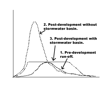
Figure 1. Effect of development and construction of stormwater basins on storm runoff.
Stormwater basins can be either dry (detention ponds) or wet (retention ponds). In some cases constructed wetlands are also used for stormwater management. Dry detention basins are grass or stone-lined depressions that can potentially be used as recreation areas during dry periods, but often they are not designed to be aesthetically pleasing. Although they lower peak flows, they provide minimal water quality treatment. Wet basins are permanent pools of water, designed to store drainage above the normal pool elevation during storm events. They are often used in current subdivisions, because many people enjoy living near water. They also have the benefit of a longer storage time (if the stormwater mixes with the permanent pool), which often results in better water quality treatment. In addition, a certain amount of water can infiltrate between storms and filter out contaminants.
Reduce Pollution Sources
It is generally less expensive to prevent contaminants from entering stormwater than to treat contaminated water. Many contaminants can be prevented from getting into stormwater through good management practices such as encouraging proper disposal of pet wastes; reducing fertilizer and pesticide use on lawns, gardens, cemeteries, and golf courses; and community hazardous waste and waste oil recycling centers. Regular street and parking lot cleaning can reduce the transport of sediment-bound pollutants. New street sweeping machines pick up much finer materials than older models. Disposal of street sweeping wastes may pose a problem because of possible high levels of lead, copper, zinc and other wastes from automobile traffic, but this clearly shows the importance of removing them before they enter streams. In areas where salt is used, alternative practices such as relying first on plowing rather than salting, anti-icing (preventative salting before a storm), or using sand, cinders, or chemicals such as calcium magnesium acetate (CMA) instead of salt will reduce pollution of area water bodies.
Establish Protected Areas such as Stream Buffers. Although all land use affects water quality, the riparian areas along the edges of streams and waterways have a particularly important effect. Buffer zones or "green belts" along streams can improve water quality while providing recreational areas for residents. Buffer zones are particularly effective at reducing streambank erosion, filtering out sediment and sediment-bound contaminants, and promoting healthy aquatic life in the stream. They also promote infiltration, and if the primary pathway followed by runoff water is overland (rather than through pipes), they will reduce dissolved contaminants. Stream buffers can be protected by regulations, purchase of the land, or easements to prevent development on the critical riparian areas. Protecting these areas usually has a disproportionately large effect on water quality and should be a priority in any development planning.
Plan development on a watershed basis
Subdivisions usually require approval by the local or area plan commission, and a detailed drainage or water management plan for the proposed development is often part of the approval process. In most cases a drainage plan for the site itself is all that is considered, rather than how the development affects the entire watershed. In order to protect streams and watersheds, a broader approach is needed.
A watershed approach would require an analysis of the watershed in which the proposed development is located, and how the proposed development fits into the cumulative impacts of all development planned in the watershed. The advantage of planning on a watershed basis is that it may be most beneficial to the stream as a whole if development is concentrated in certain high-density areas, while other areas are left as open space. Another aspect of watershed-based planning is preparing an inventory of important natural resources throughout the watershed, and implementing setback distances from critical resources. Development should be concentrated in areas that are not classified as critical resources. Geographic Information Systems (GIS) can make the analysis of larger areas more feasible.
The Future back to top
Stormwater runoff is one of the leading remaining causes of water quality problems in the United States. Cities over 100,000 people have already been required to respond to stormwater runoff rules which required that they obtain Clean Water Act (NPDES) discharge permits. Phase II stormwater regulations expand controls of storm water runoff to cover smaller cities (with populations under 100,000) and small construction sites (under five acres). The proposed stormwater regulation, which will be finalized in 1999, promotes public education and outreach on stormwater impacts, public involvement and participation in stormwater planning, and the use of best management practices to minimize stormwater impacts as part of a municipal stormwater program.
There is no doubt that it is easier to plan for good stormwater management before development takes place rather than retrofitting existing development to reduce stormwater impacts. Balancing the needs of growth and protection of the environment (particularly streams, rivers, and lakes) requires planning and commitment, but it is well worth the effort. All citizens benefit when clean streams with healthy aquatic life flow in and around their communities.
Acknowledgments back to top
This publication was strengthened through thoughtful reviews by the following Purdue University faculty:
- Bernard Engel, Department of Agricultural and Biological Engineering
- Jon Harbor, Department of Earth and Atmospheric Sciences
- William Hoover, Department of Forestry and Natural Resources
Author back to top
Dr. Jane Frankenberger is an Assistant Professor in Agricultural and Biological Engineering at Purdue University. Her research interests are in hydrologic modeling, geographic information systems, and hydrologic transport of nonpoint source pollutants. Her statewide extension programs include agriculture and water quality, drainage, GIS, wellhead protection, and watershed protection.
References & Additional Resources back to top
Crawford, C.G. 1996. Influence of natural and human factors on pesticide concentrations in surface waters of the White River basin, Indiana. U.S. Geological Survey Fact Sheet 119-96.
Northeastern Illinois Planning Commission. Date? Pavement Deicing: Minimizing the Environmental Impacts. 222 S. Riverside Plaza, Suite 1800, Chicago IL 60606.
USEPA. 1982b. Results of the Nationwide Urban Runoff Program, Volume II - Appendices. U.S. Environmental Protection Agency, Water Planning Division, Washington, DC.
The Purdue University/EPA Web site. "Long-Term Hydrologic Impact Assessment" enables the user to input any combination of land use and soil type and find the long-term runoff amounts. The program can be found at http://danpatch.ecn.purdue.edu/~sprawl/LTHIA
For more information
contact Jane Frankenberger
(frankenb@purdue.edu)
or Brent Ladd (laddb@purdue.edu)
or call the Purdue Extension Safe Water office at 765-496-6331

Purdue Equal Opportunity Statement
Home | Wellhead Protection | Farm/Home *A*Syst | Drinking Water FAQs | Publications | Safe Water for Kids | Links