|
LaPorte County Geology
LaPorte County is located within the glaciated portion of the
state and can be divided into three physiographic regions as shown
in Figure 8. Physiographic regions are areas of characteristic
soils, landforms and drainage that have been developed on geologically
similar materials.
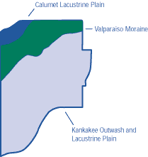 |
| Figure 8. The three major
physiographic regions in LaPorte County. |
The Calumet Lacustrine Plain lies on the border of Lake Michigan
and consists of sand dune ridges and wet flat areas. Most soils
are formed in eolian, or wind-blown deposits.
The Valparaiso Moraine is higher in elevation than the other
parts of the county, and separates the Lake Michigan from the
Kankakee watershed. Depressions called “kettle holes” are present
along the northern slope of the moraine. Large kettle depressions
are now lakes, while small depressions are filled with sediment
including peat and muck.
The Kankakee Outwash and Lacustrine Plain is nearly flat, with
few natural drainage channels. Before modern drainage, most of
this area consisted of wetlands.
|