
SNOOPI, an experimental satellite to test and validate a new instrument and technique for Earth remote sensing, was released into low Earth orbit on April 18, 2024, from the International Space Station. This project, led by professor James Garrison is a proof-of-concept mission to determine if communications satellite signals reflected from Earth can be used to measure soil moisture below the surface. It is funded by NASA’s Earth Science and Technology Office and was conducted in collaboration with NASA’s Goddard Space Flight Center and Jet Propulsion Laboratory.
After confirming solar panel deployment, a power positive state and instrument antenna deployment, the SNOOPI team began making regular contacts with the small satellite from NASA Direct-to-Earth (DTE) tracking stations. This cubesat is the first in-space demonstration of using “signals of opportunity” from non-cooperative communication satellites for Earth remote sensing.
SNOOPI is designed to monitor signals in P-band, around 300 MHz, which are used for basic satellite communications. The key advantage of this method is that these frequencies can reach five times deeper into soil and snow.
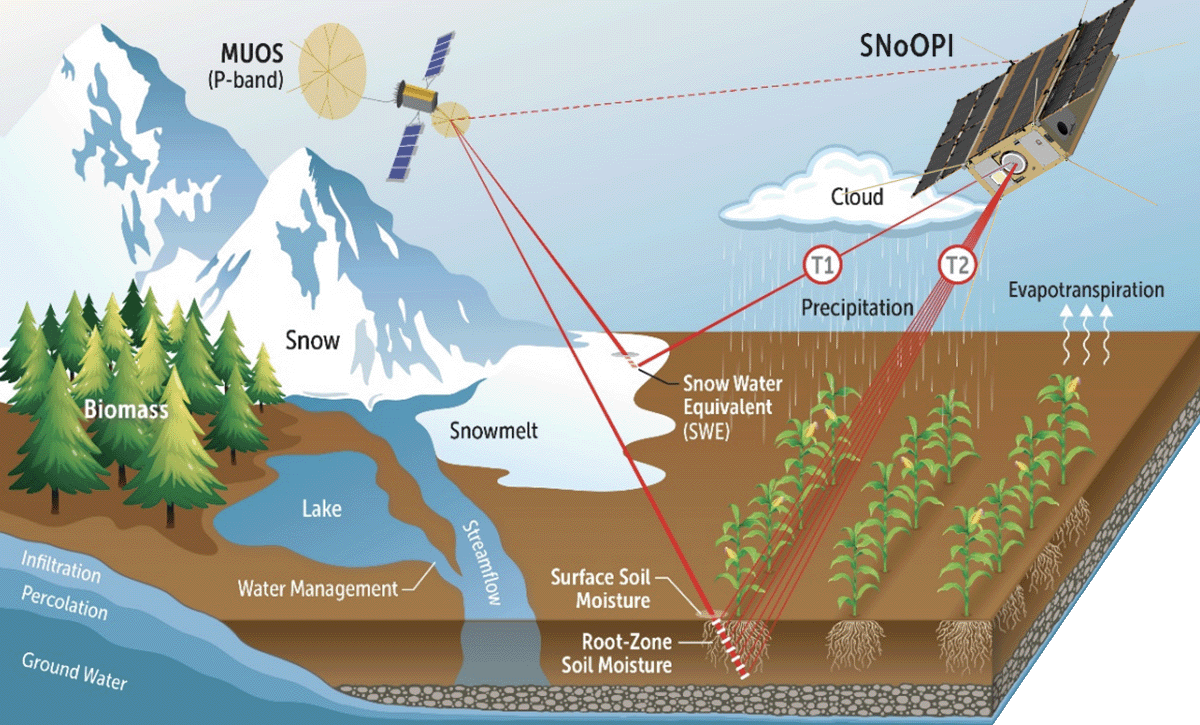
This diagram shows how the SNOOPI cubesat reads communications signals reflected from Earth to calculate soil moisture.
“This allows a direct measurement of the moisture contained within the root zone, the layer of soil in which most plant roots exist to absorb the water,” Garrison says. “Monitoring of this region provides an important connection between water contained within the soil and that in the atmosphere.”
Future missions could use SNOOPI’s technology to globally monitor how much water is stored below the surface of the soil and in the snowpack. Earth-monitoring via signals of opportunity (SoOp) could predict droughts and floods, assist with forecasting agricultural yields, monitor trends in climate change and even be applied for predicting wildfire risk. This ability can provide critical information for an increasingly shifting world when it comes to weather, rainfall and climate-smart agriculture. By better understanding where water is, we can predict where it might go and how it can help various stakeholders be more climate resilient.
To support the SNOOPI mission, a monitoring station, shown with Garrison and his students, was installed at Purdue’s Agronomy Center for Research and Education in 2023. The antenna array collects accurate measurements of the signal power and spectrum of the non-cooperative source for radiometric calibration of reflected signal measurements.

AAE Professor Jim Garrison stands with his students in front of the antenna array installed at Purdue's ACRE site to communicate with SNOOPI.
The SNOOPI mission ended on Sept. 28, 2024 when it reentered. The team is now studying the data collected from the prototype instrumenta-tion to compare against models and observations from various instrumented ground sites.
This proof-of-concept mission follows decades of Garrison’s work. He performed some of the earliest research on SoOp. He was also on the science team for NASA’s Cyclone Global Naviga-tion Satellite System (CYGNSS) mission, which used this technique to measure wind speed over oceans. Garrison was also elevated to fellow of the Institute of Electrical and Electronics Engi-neers (IEEE) for his contributions to the SoOp field, and his students have earned prestigious research grants for related work.
SNOOPI is a NASA ESTO funded collaboration between Purdue University, NASA GSFC and NASA JPL.