|
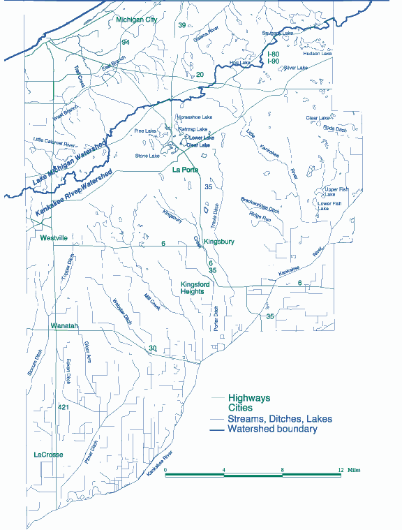
LaPorte County Streams and Watersheds
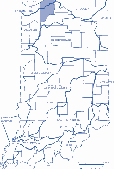 |
| Figure 1. Major Watersheds
of Indiana. |
A watershed is a region of land that drains into a lake, stream,
or river. Watersheds are important because everything that is
done on the land within a watershed can affect the lake or river
into which it drains. The quantity and quality of our water is
affected not only by what might be dumped in the river, but by
everything we do on the land in the watershed.
Watersheds can be any size. A few acres of land that drains
into a pond form a watershed. If that pond drains into a stream,
those acres, along with many others, are part of the watershed
for the stream. Small watersheds are part of larger watersheds,
just as small streams flow into larger streams.
LaPorte County is located within two major watersheds of the
United States. The northern third of the county is in the Great
Lakes (Lake Michigan) watershed, while the southern two-thirds
is in the Mississippi River (Kankakee) watershed. (The dividing
line roughly follows the Indiana Toll Road, as shown in Figure
1). Precipitation that falls north of the divide flows north to
Lake Michigan, through the other Great Lakes to the St. Lawrence
Seaway and eventually to the Atlantic Ocean. Water south of the
divide flows generally south to the Kankakee River, which flows
west into the Illinois River, then into the Mississippi River
and the Gulf of Mexico.
Lake Michigan Watershed
The major portion of the Lake Michigan Watershed in LaPorte County
flows to Trail Creek, which empties directly into Lake Michigan.
The Little Calumet River, which flows through Porter County to
Lake Michigan, drains a small area in the southwest part of the
watershed. The northeastern portion of the county drains into
the Galena River, which flows north to Michigan, then into Lake
Michigan. The landscape in the Lake Michigan watershed is characterized
by dunes, including Mt. Baldy, Indiana’s largest migrating sand
dune.
Kankakee Watershed
The southern part of the county is drained by many ditches and
streams which flow into the Kankakee River. The natural drainage
in this area has been altered through the installation of an extensive
network of ditches and field tile. The Kankakee River itself was
dredged and straightened in the early 1900’s to provide quicker
removal of water. This was done to create agricultural land, and
has resulted in a great change of the landscape.
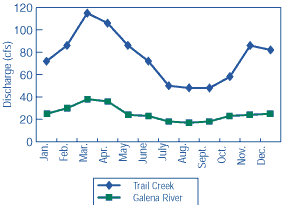 |
| Figure 3. Average monthly
discharge for LaPorte County streams. |
Discharge for a stream or river is the amount of water flowing
per unit of time. A typical unit for measuring discharge is cubic
feet per second (cfs). Four gauging stations, where discharge
is measured continuously in a stream or river, are run by the
U.S. Geological Survey in LaPorte County. These four stations
are located in Trail Creek at Michigan City, Galena River near
Heston, Kingsbury Creek near LaPorte, and the Kankakee River on
the St. Joseph County border. The monthly average discharge for
two of these streams is shown in Figure 3. Highest flows generally
occur in the spring (February-April) while Floodplains are low
areas adjacent to river or stream channels and lakes.
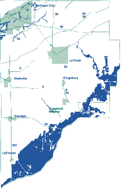 |
| Figure 4. Floodplain of LaPorte
County. |
Floodplains exist because these channels are rarely large enough
to contain major floods. These areas have flooded in the past
and will flood again in the future. Floodplains have been delineated
for parts of LaPorte County by the Federal Emergency Management
Agency. A very general map of floodplains is shown in Figure 4.
The LaPorte County Health Department has maps that show detailed
boundaries of floodplains, which should be viewed before planning
any development that may be partly within a floodplain.
|