|

As local land use decisionmakers, municipal and
county leaders regularly measure the benefits and costs of development
proposals. In addition to factors such as the extension of existing
infrastructure and the delivery of government services, local officials
are beginning to consider the impact that land use changes will
have on a community's water quality.
Land use changes can significantly impact groundwater
recharge, stormwater drainage, and water pollution. The Long-Term Hydrologic Impact Assessment (L-THIA) model was developed as an accessible online
tool to assess the water quality impacts of land use change. Based
on community-specific climate data, L-THIA estimates changes in
recharge, runoff, and nonpoint source pollution resulting from past
or proposed development. As a quick and easy-to-use approach, L-THIA's
results can be used to generate community awareness of potential
long-term problems and to support planning aimed at minimizing disturbance
of critical areas. L-THIA is an ideal tool to assist in the evaluation
of potential effects of land use change and to identify the best
location of a particular land use so as to have minimum impact on
a community's natural environment.
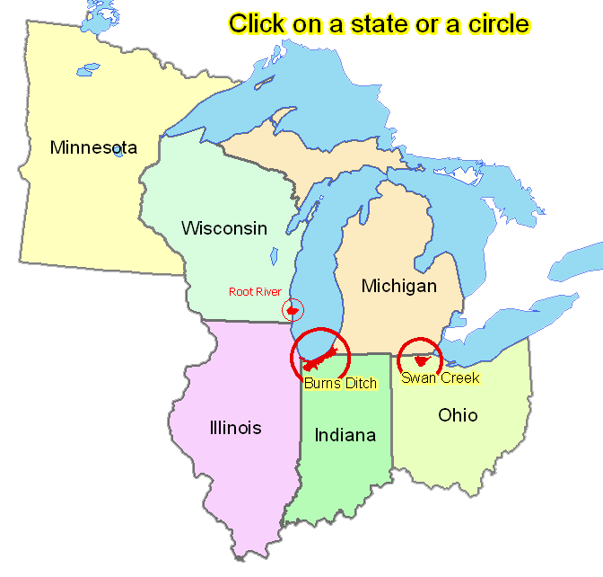
Differences Between the Models
- Basic L-THIA
Users only need to input their location, soil type, and the type
of land use change taking place.
- Impervious L-THIA
Allows users to input the percentage of impervious cover of different land uses.
- L-THIA LID
Allows users to estimate impacts of sustainable development and low-impact practices ( rain barrels, rain gardens, pervious pavers, green roofs, etc.)
-
Related
Tools
Other tools from the developers of L-THIA
Background Information
For additional information, contact:
Bernie Engel, Purdue University
Jon Harbor, Purdue University
  
(C) Copyright, 2004 by Purdue Research Foundation, West Lafayette, Indiana 47907. All Right Reserved.
|