County Maps of Water Supply Watersheds in Indiana
In Indiana,
52 community water supply systems use surface water (lakes, rivers, streams) as
the source of their drinking water. These systems are particularly vulnerable
to contamination from certain chemicals that are transported primarily by
runoff, such as atrazine and other pesticides. This site provides maps of the
watersheds for each of the systems, divided by county. There are three ways to
access the county maps.
- A clickable
state map, from which county maps are available for each county
that intersects a water supply watershed
- Powerpoint
files, with about 10 counties included in each file. (Each file is
less than 1 MB). Counties not included do not intersect any of the water
supply watersheds.
- Allen to Crawford
- DeKalb to Fulton
- Gibson to Huntington
- Jackson to Monroe
- Noble to Rush
- Scott to Whitley
(For Educators: Link to Video
explaining these maps – takes about a minute to load, and requires Windows
Media Player)
- A pdf document (approximately 5
MB) of the 52 counties
Counties that are not included do not intersect any of the
water supply watersheds. A list of counties that intersect
water supply watersheds is available here.
How to interpret these maps
Each county map shows the watersheds located within the
county for all public water supply systems that provide drinking water from
surface water sources (streams, rivers, or reservoirs). Watersheds for public
water systems are important because activities or chemicals applied within them
have the potential to impact drinking water quality.
Watersheds can be large or small, ranging from less than 2
square miles in areas to more than 5000 square miles. Watersheds for Lake
Michigan (source water for Hammond, Lowell, Whiting, East Chicago,
Indiana-American Northwest, and Michigan City)
and the Ohio River (source water for Evansville)
are so large that they are not included on these maps.
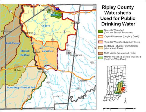 A
county may include watersheds for communities that are not located within the
county. In the map of Ripley County shown at left, drinking water supply
watersheds are shown for Batesville, Osgood, and Versailles
which are in the county, and also for North Vernon, Mitchell, Bedford,
and Scottsburg which are located some distance from Ripley County.
Activities in Ripley
County can affect
communities tens or hundreds of miles downstream. The smaller inset map of Indiana shows the entire
watershed for more perspective.
A
county may include watersheds for communities that are not located within the
county. In the map of Ripley County shown at left, drinking water supply
watersheds are shown for Batesville, Osgood, and Versailles
which are in the county, and also for North Vernon, Mitchell, Bedford,
and Scottsburg which are located some distance from Ripley County.
Activities in Ripley
County can affect
communities tens or hundreds of miles downstream. The smaller inset map of Indiana shows the entire
watershed for more perspective.
Watersheds are often nested within other watersheds, since
one water system may draw water upstream from another on the same stream or
river. In those cases multiple outlines show the relationship between
watersheds. For example, in Ripley County both Osgood and Versailles
use Laughery Creek, with Osgood’s water intake upstream from Versailles. Therefore the
watershed for Versailles
(plum outline) encompasses the entire Osgood (orange outline) watershed, plus
an additional downstream area. Batesville (green outline) draws water from
smaller reservoirs that are also within the Laughery Creek watershed, and its
watershed is fully contained by both Osgood and Versailles. Therefore, the outline for Versailles extends all
the way around the Osgood and Batesville watersheds as well. Also, North Vernon and Scottsburg-Stucker Fork watersheds lie
completely within the watershed for Mitchell and Bedford, which is shown with
the dark green line extending around these watersheds.
Watershed names are shown on all maps in blue, while the
names of communities are in black. County boundaries, rivers, and highways are
shown for reference.
For more information, please contact Jane Frankenberger,
Associate Professor and Extension Specialist (frankenb@purdue.edu).