
Indiana
Compressed with MrSID, organized by county on CD-ROM
The 1998 orthophotography for
The CDs have been distributed for several years, and we are now giving the
remainder away to those who can use them. The CDs will be most useful for
people without high-speed internet
access, who need photos from around
(More current and higher resolution photos are now available for those with good internet access – see http://pasture.ecn.purdue.edu/~frankenb/2005orthophotos/ for more information, or of course you can just use http://maps.google.com to see the recent color photos quickly.)
The 1998 black and white photos have a 1-meter resolution. They are the same photos viewable on http://www.terraserver-usa.com/. They require GIS software for viewing. MrSID is an acronym for Multi-resolution Seamless Image Database. Almost all GIS software packages can view the MrSID image format. Examples are ArcView 3, ArcGIS, and ArcExplorer (free from ESRI).
(Sept 21, 2007): To obtain CDs,
please stop by ABE 208 between 8:00 and 4:30 pm. First come, first served.
How the 92 Indiana
1 Lake, LaPorte, Porter
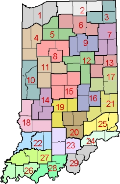 2 St. Joseph, Elkhart, Lagrange
3 Steuben, Noble, DeKalb
4 Jasper, Newton, Benton
5 Pulaski, Starke, Fulton
6 Marshall, Kosciusko, Whitley
7 Allen, Adams, Wells
8 White, Cass, Carroll
9 Miami, Wabash, Huntington
10 Warren, Fountain, Vermillion, Parke
11 Tippecanoe, Montgomery, Clinton [NO LONGER AVAILABLE]
12 Howard, Tipton, Grant, Madison
13 Delaware, Blackford, Jay
14 Putnam, Owen, Clay
15 Boone, Hamilton, Hendricks, Marion
16 Hancock, Shelby, Rush
17 Henry, Randolph, Wayne
18 Vigo, Sullivan, Greene
19 Monroe, Morgan, Johnson
20 Brown, Bartholomew, Jackson
21 Decatur, Franklin, Union, Fayette
22 Knox, Daviess, Martin
23 Lawrence, Orange, Washington
24 Scott, Jefferson, Switzerland
25 Jennings, Ripley, Dearborn, Ohio
26 Posey, Vanderburgh, Warrick
27 Gibson, Pike, Dubois
28 Spencer, Perry, Crawford
29 Harrison, Floyd, Clark
Software for viewing the MrSID-compressed orthophotos
Many software programs, such as ArcView or ArcGIS,
can interpret images compressed with MrSID. We have
listed free viewers and GIS software that can easily open these images.
Free software
- ArcExplorer data browsing software can display, query, and retrieve GIS data. It is available from ESRI .
- Two viewers, the MrSID Viewer and the MrSID GeoViewer are available from Lizard Tech. Both can display images with high quality resolution, but can only load one image at a time. The GeoViewer is a larger download than the Viewer, but it offers tools more applicable to the GIS world.
Geographic information about the orthophotos
The geographic extent of the digital orthophoto is equivalent to a quarter-quadrangle (3.75 minutes of latitude and longitude), plus 50 to 100 meters of overlap. Each image covers roughly 10,000 acres.
The uncompressed resolution is 1 meter. Resolution is the minimum distance between two adjacent features, or the minimum size of a feature that can be detected by a remote sensing system. The quality of the image is slightly degraded due to the compression in MrSID.
The projection used for these photos is Universal Transverse Mercator (UTM). The datum is the North American Datum of 1983 (NAD83), with coordinates in meters.
The orthophotos conform to National Map Accuracy Standards at the scale of 1:12,000. This means that 90 percent of the well-defined points tested must fall within 33.3 feet (1/30 inch) of their actual position.
The images on this CD-ROM have been compressed by a factor of ten. Each quarter quad is approximately 5 MB, and the entire state is about 12.5 gigabytes compressed at this ratio.
For more information
For a discussion of orthophoto use and
specifications, see http://edc.usgs.gov/glis/hyper/guide/usgs_doq/
The complete description is Standards for Digital Orthophotos (Reston, Virginia, U.S. Geological Survey, 1996), available at http://rockyweb.cr.usgs.gov/nmpstds/doqstds.html.