
Watershed Protection
Since the enactment of the Clean Water Act, the United States has spent billions of dollars every year to fight water pollution. Nevertheless, recent water quality assessments indicate that excess silt, nutrients, pathogens, and pesticides still pollute the nation's water resources. A more comprehensive watershed protection approach is therefore needed to restore and maintain our waters. According to the EPA, the watershed protection approach has four major features:
- targeting priority problems,
- a high level of stakeholder involvement,
- integrated solutions that make use of the expertise and authority of multiple agencies,
- measuring success through monitoring and other data gathering.
Steps in watershed protection
-
Watershed Delineation
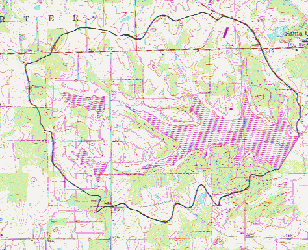
The first step in watershed protection is to delineate the watershed boundary for the reservoir, river, or lake used for water supply, based on topographic data. An example of watershed delineation is shown for Christmas Lake in southwestern Indiana at the right. Christmas Lake is in Spencer County, and serves as the public water supply for the town of Santa Claus (seriously!). The watershed was delineated on a USGS topographic map at the scale of 1:24,000.
-
Identification of potential sources of contamination
The second step in a watershed protection program is to identify both point and nonpoint potential sources of contamination in the identified watershed.- Point sources may include waste water treatment plant discharge, stormwater drains, industrial discharge and other permitted discharge. Application of aquatic herbicides to the lake can also be considered a point source. Spills from sites where potentially hazardous products are stored such as animal waste lagoons, pesticide or fertilizer storage, and hazardous or other solid waste landfills are other potential point sources.
- Potential nonpoint sources exist on much of the
landscape. Application of pesticides, fertilizer, and animal manure
is widespread on agricultural land, impervious surfaces, such as
roads and parking lots, can discharge chemicals and road salt, and
residential areas may have failing septic systems.
-
Identification of critical areas
Numerous studies have established that certain parts of a watershed contribute more to water quality degradation than others. These critical areas can be defined from distance to the watercourse, high runoff caused by soil, geologic, and topographic properties, and potential pollutants applied to the land. Critical areas may include:- The area immediately adjacent to streams and reservoirs
- concentrated flow areas, where channelized surface runoff is most likely to occur
- impervious areas such as parking lots
- ephemeral channels including surface drains and diversions
- other areas identified using topographic, soil,
and land use data where transport of pesticides or other nonpoint
source pollutants to water supplies is probable.
-
Develop Watershed Protection Strategies
The fourth step is to develop watershed protection strategies, which will differ for point and nonpoint sources. Potential point sources must follow state and federal regulations, so local efforts may focus more on compliance and emergency plans in case of accidental spills or other contamination. Prevention of nonpoint source pollution may involve installation of BMP's in the critical areas identified above.
Other world wide web sites related to watershed protection:
- Know your watershed is a nationwide program organized by the Conservation Technology Information Center.
- Locate your watershed and resources found within it using the Interactive Watershed Map. Click on the large basin to obtain a map of watersheds and then click on the smaller watershed.
- Land use plays a major role in watershed protection. Information on land use planning is available from the Purdue University Agronomy Department.
- EPA resources for watershed protection (a great list of "tools")
- Nonpoint Education for Municipal Officials. NEMO uses geographic information system (GIS) images as tools to educate local land use decision makers about the linkages between land use and water quality and what they can do to prevent and manage nonpoint source pollution in their watersheds.