Erosion Control Principles
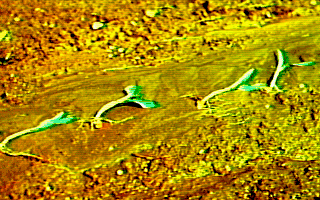
 Erosion-laden Runoff
Note these materials have largely been developed
by Larry Huggins for use in AGEN 521.
Goal:
To understand the erosion process
and the forces involved.
This is vital to the ultimate
goal of quantitatively predicting
field soil loss, the essential first step in planning
control strategies and practices.
Scope:
Wind erosion is a serious problem
in many parts of the world; within the U.S.
the southwestern Great Plains have been
classified as a potential "desertification" region.
Nevertheless, this course's focus is on water erosion since water erosion
is a much larger problem in the midwest.
The erosion prediction methodologies covered in this
section all are derived from the Universal Soil Loss Equation.
Introduction:
Sediment is introduced into our water resources through
the erosion process.
It is the number one polluter, quantity-wise
at least,
of our water resources.
Sediment itself is detrimental to fish propagation
and recreational uses of lakes and streams.
Sediment also transports chemicals, especially phosphorus,
which cause rapid
eutrophication (aging) of
those bodies of water.
Perhaps more serious than the degradation of our water
resources, which often can recover reasonably
quickly after erosion is abated, is the harm erosion causes to the long-term
productivity to our land resources.
Thus, erosion control yields dual benefits, sustainable
production and improved water quality.
The Erosion Process
The terms interrill and
rill erosion
have gained wide acceptance because they
can be quantitatively described.
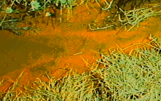
So-called sheet erosion,
-
the uniform loss of
a thin layer over a large area, rarely occurs.
However, it appears to occur because storm-caused
rills are smoothed out by tillage tools.
Visible effects of "sheet" erosion are seen in
turbid waters and on the lower elevations of
fields as depicted in this field.
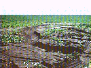
Interrill erosion is caused mainly by raindrop
splash and "film" flow between rills.
Its action is the same regardless of position
on the slope.
Rill erosion is caused mainly by runoff.
As runoff waters are progressively collected by
rills they tend to become larger in the downslope
direction and are also more noticeable.
Thus, while rill erosion is the more visible of
the two, the amount of soil moved by raindrop
splash is much greater.
Erosion (also sedimentation) is a non-uniform,
unsteady process with both transportation and
deposition occurring simultaneously.
The forces causing water erosion can be categorized
as:
-
Attacking Forces:
- Those which cause detachment
and transport of soil particles.
These forces are produced by rainfall and runoff.
For a unit mass of water,
larger raindrops and faster flowing runoff have
greater energies for causing erosion.
-
Resisting Forces:
- Those which tend to either
stabilize the soil (increased cohesion or weight)
or reduce the magnitude of the attacking forces
(increased infiltration, better canopy, or
increased surface roughness).
Vegetation is especially important in that it intercepts rainfall,
restrains soil movement,
improves infiltration, decreases runoff velocities,
and improves soil aggregation.
Erosion prediction
Effective control of soil erosion requires
an ability to quantitatively to predict the amount
of soil loss which would occur under alternate
management strategies and practices.
Without question, the model with the greatest
acceptance and use, especially within the U.S.,
is the Universal Soil Loss Equation, USLE,
developed by ARS scientists W. Wischmeier and D. Smith.
While newer methods are now becoming available,
most are still founded upon principles introduced by
the USLE; thus, understanding those principles is quite important.
USLE states that the field soil loss in tons
per acre, A, is the product of six causative factors:
-
-

- where:
- R = rainfall and runoff erosivity index
- K = soil-erodibility factor
- L = length of slope factor
- S = degree of slope factor
- C = cropping-management factor
- P = conservation practice factor
The R-term characterizes the level of
attacking forces while the remaining terms characterize
the level of resisting forces.
Values for the various factors (except K)
were based on a statistical analysis of data
gathered from plots.
The K-factor was determined experimentally in
tons per acre as:
-
-

- for the conditions when:
- S = 9 percent
- L = 72.6 feet
- C = fallow
- P = up-and-down hill farming = 1
This model was put into its present developmental
form during the 1950/60s by Mr. W.H. Wischmeier who held a joint
appointment with USDA and the Department of Agricultural
Engineering here at Purdue.
The model is a phenomenological one (predicts the effect)
and does not give a good idea of
the actual mechanisms involved.
Evaluating the factors in USLE:
R, the rainfall factor:
- Most appropriately called the erosivity index;
it is a statistic calculated from the annual summation of rainfall
energy in every storm (correlates with raindrop size) times its
maximum 30-minute intensity.
Empirically, this "EI-Index" was found to have the highest
correlation with soil erosion from experimental plots.
As expected, it varies geographically,
but its seasonal distribution is also important to calculate C-values.
K, the soil erodibility factor:
- This factor quantifies the cohesive character
of a soil type and its resistance to dislodging and
transport (particle size and density dependent) due
to raindrop impact and overland flow shear forces.
Some values are given in Table 6.1;
however, we are now able to estimate K
knowing certain soil properties.
LS, the topographic factor:
- Steeper slopes produce higher overland flow
velocities.
Longer slopes accumulate runoff from larger areas
and also result in higher flow velocities.
Thus, both result in increased erosion potential,
but in a non-linear manner.
For convenience L and S are frequently lumped
into a single term.
(See Fig. 6.5).
-
C, the cropping-management factor:
- This factor is the ratio
of soil loss from land cropped under specified
conditions to corresponding loss under tilled,
continuous fallow conditions.
The most computationally complicated of USLE factors,
it incorporates effects of: tillage management (dates and types),
crop, seasonal EI-index distribution, cropping history (rotation),
and crop yield level (organic matter production potential).
-
P, the conservation practice factor:
- Practices included in this term
are contouring, strip cropping
(alternate crops on a given slope established
on the contour),
and terracing.
As a rule of thumb,
contouring reduces to one-half the soil loss
caused by up-and-down hill farming,
strip cropping to one-half that of contouring,
and terracing to one-half that of strip cropping.
(See Table 6.3).
RUSLE
RUSLE is the Revised USLE. RUSLE has been revised in several
ways, but the most important is that it is a computer program
as opposed to a series of USLE tables and figures.
You will have an opportunity to use RUSLE in lab to
estimate soil erosion for 2 scenarios.