Note these materials have largely been developed by Larry Huggins
for use in AGEN 521.
Vegetated Waterways:
The purpose of vegetated waterways is to protect
the soil against erosive actions of concentrated
flow.
They have many uses in a comprehensive conservation
plans, but primarily they collect and concentrate
flows and then safely transport the water to major drainage systems.
Dense vegetation is used to minimize
the area required, i.e. the protective action
of the vegetation permits higher flow velocities and
thus smaller waterway cross-sections.
Most vegetated waterways run directly down
a slope; however, they can also be constructed somewhat across
the slope as diversions or sometimes to just
reduce channel slope.
Vegetated channels should not be used where continuous
flow occurs because the vegetation will die out.
Base flow, even for short periods, can usually be controlled
by one or more tile drains laid either directly
under or alongside a watercourse.
Tillage near a waterway
should be accomplished in a direction essentially across the waterway.
Grass cover should be cut periodically,
fertilized as needed,
and not subjected to prolonged traffic by either
livestock or vehicles.
-
Channel Shapes:
-
There are basically three shapes to be considered for
vegetated waterways:
triangular, parabolic and trapezoidal shapes.
The triangular shape concentrates low flows
if the "V" is not smoothed out during the construction
process with a tillage tool.
On the other hand,
the flow tends to meander on the flat bottom of
a trapezoidal waterway.
The parabolic shape is the most stable shape.
Often, however, the shape is decided based on available equipment.
A triangular shape is usually made using a motorized grader,
a trapezoidal shape by a motorized scraper or pan,
and a parabolic shape with a bulldozer going back
and forth across the waterway.
-
Channel lining and permissible velocity:
- Grass linings should be hardy, dense-growth perennials
adapted to the geographical region and soil.
Waterways are usually constructed in this
area during August and September because that
coincides with the time of the year when most perennial
grasses are best established.
A permissible velocity for the chosen channel lining,
the existing soil based on its resistance to erosion,
and the established slope is given in Table 7.3.
-
Waterway dimensions:
- The waterway dimensions can be determined by
simultaneously solving two equations for the waterway depth,
d, and the channel top width, t, or bottom width, b.
One equation is the continuity equation, an equation for the discharge or
capacity of a channel.
- The capacity of the channel,
q, is usually sized to handle runoff from the watershed
for a 10-year return period storm.
The other equation is a velocity equation called Manning's formula.
This is an empirical formula, i.e. not
dimensionally consistent.
Determining channel dimensions to handle a specified
flow rate requires an iterative solution of the
continuity and Manning's equations.
Nomographs provide a quick solution.
-
Waterway failures:
- Failure generally occurs when a waterway is overtopped.
Alternate flow paths become established, usually just alongside the
vegetated waterway.
Common causes of failure are sedimentation
(due to excessive watershed erosion),
improper edge cultivation
(due to plowing, etc. parallel to the waterway),
over-grazing and trampling by livestock,
and low, longtime flows, i.e. base flows.
Proper edge cultivation is accomplished by raising or lowering
tillage tools in an
irregular manner as the waterway is crossed.
Low, longtime flows can be prevented by placing
subsurface drains alongside the waterway.
Contour Practices
We will use this term to refer only
to those mechanical practices of
contouring, strip cropping and terracing.
These three practices require the adjustment of tillage
operations to on or near the contour and
give more-or-less permanent protection
against erosion.
They influence values of
the cropping and management factor, C, and
the conservation practice factor, P, in the USLE.
Reduced or conservation tillage will be used to refer
to a collection of tillage practices carried out
without regard to topographic conditions.
With conservation tillage some or all of the crop
residue remains on the surface and it
is usually left in a rough condition.
While influencing only the C-factor of the USLE, conservation
tillage nearly always results
in a significant reduction in soil erosion.
Various forms of conservation tillage are now fairly widespread, especially
in the intense mid-agricultural sections of the U.S.
Most farmers are aware of the serious nature of soil
erosion, but must balance real conflicts with labor,
machinery, pest and disease control,
and the speculative nature of today's agriculture when
implementing erosion control measures.
-
Contouring:
- Contouring farming entails performing all tillage
operation on or near the same elevation or "contour".
It is accomplished by putting one or more
guide lines
in a field and then starting tillage operations
from these guide lines.
Contouring is applicable on relatively short slopes
up to about 8 percent steepness with fairly stable soils.
Contouring's impact on annual soil loss rates vary with slope steepness,
but typically it's reduced on the order of one-half from up-and-down
hill farming when the slope is between 4 and 7 percent.
The disadvantages of contouring are
point rows and break-overs
caused by reduced water storage capabilities behind
the contour ridges as the slope increases.
Once a break-over occurs it is likely to progress
all the way down a slope as the runoff volume increases.
Break-overs are a definite hazard on slopes greater
than 10 percent.
On steeper slopes erosion control may have to
be accomplished through vegetative means,
i.e., grass or timber.
The advantages of contouring are:
the velocity of runoff is checked;
the adsorption of rainfall is increased;
erosion is reduced by slowing the rate of runoff;
and, temporarily storing runoff behind contour ridges
increases infiltration and collects sediment.
Strip Cropping:
- Strip cropping is a combination of contouring
and crop rotation
in which alternate strips of
row crops and closely grown crops such as meadow or
a small grain are grown on the same slope.
C-C-W-M is a good rotation for strip cropping
since it has the same number of years for corn
as for wheat and meadow.
Strips generally vary from 50 to 130 feet in the Midwest.
In general, strip cropping is applicable to a steeper
but mainly longer slope than contouring alone.
Values of A are reduced on the order of one-half
that for contouring.
The advantages and disadvantages of strip cropping
are similar to those for contouring.
Strip cropping also tends to filter out the soil
in the runoff through the strip with the closely grown crop.
On the negative side,
one crop may tend to harbor (host) plant diseases and
pests which are detrimental to the other crop.
Terracing:
- Terracing is a combination of contouring and land
shaping in which the slope length is reduced by the
construction of ridges or channels across the slope.
The two types in common use in the U.S. (in contrast to
the very steep areas with bench terraces in older countries
as shown in the title graphic of this lesson) are broad-based,
graded terraces and pto terraces.
Both are named after their means of outleting water.
Graded terraces are constructed as channels with a slight
cross-slope grade to outlet water into surface waterways.
PTO terraces
pond water which is then slowly released through underground tile lines.
Terraces are suitable on slopes similar
to contouring but preferably with long slope lengths.
Long terrace lengths are also desirable because of
the high initial costs associated with land forming.
Values of P are reduced on the order of one-half that
of strip cropping.
However, annual loss is further reduced because the
L-factor is the terrace spacing interval
rather than the entire slope length.
Advantages of terracing are similar to those
for contouring, but since erosion is better controlled
the land can be farmed more intensively.
Most modern terraces are also parallel and
then spaced to fit exactly with farm machinery.
The primary disadvantage of terracing is the
expense, ranging from $300 to $500 per acre.
PTO terrace:
- A PTO terrace system incorporates the parallel
concept so terrace ridges are high when
crossing natural drainage-ways and low or even
non-existent (may be channels) when
crossing natural ridge lines.
The parallel feature eliminates points rows
between terraces.
The PTO terrace also reduces peak runoff rates
substantially and eliminates the need
for waterways.
The ridge top of a PTO terrace is at a constant elevation.
Then as the terrace crosses a natural drainage-way
it acts as a dam ponding runoff water behind it.
This water can be released slowly through a tile system.
The recommended temporary storage for PTO terraces
in this area of the United States is 2-inch of runoff.
The tile system is designed to release it in 24 hours.
Peak runoff rates are therefore reduced on the
order of 10 to 20 times over that which would
have normally occurred.
One can easily visualize that gully production
below a PTO terraced field could be virtually eliminated.
One of two terrace cross-sections are generally used:
the broad-based terrace over which machinery may
operate or the steep back-sloped terrace with
the back-slope usually grassed.
If constructed from the downhill side,
the steep back-sloped terrace also tends to
form a bench similar to the benched terraces
in the Far East used for rice culture.
-
Conservation Tillage:
- The most rapidly growing conservation practice is a
variety of techniques classified as "reduced tillage practices." These
range from substitution of a chisel plow (which leaves
crop residue on the surface) for traditional moldboard
plowing to "no-till" systems.
The major reasons such practices are gaining
acceptance are increased knowledge about what soils and topographies
are most responsive \f2and\f1 the availability of
special equipment and chemicals to support these tillage methods.
The combination of those forces has made these practices more
profitable that conventional tillage.
Thus, it's the opportunity for increased profitability that
has caused accelerated adoption, probably more so than increased
environmental concern.
Conservation Structures
The purpose of erosion control structures is to transfer
runoff from a higher to a lower elevation over a
short distance without allowing erosion to occur.
In addition to dissipating flow energy,
some structures also act to retain earth, i.e.,
they act like a retention wall.
They are especially effective in arresting gully development,
a situation which might need both a structure(s)
and some vegetated channel.
-
Types of Structures:
- Basically there are three types of structures:
drop spillway with box- or straight-inlets.
chute
pipe spillway
The drop spillway can handle a high discharge rate but
is limited with regard to overfall height.
Because the vertical headwall also acts as an
earth retention structure,
cost becomes prohibitive when the headwall
width exceeds 10 feet.
On the other hand,
a pipe spillway can transfer runoff over wide ranges
in elevation, but is limited with regard to discharge.
Flow is totally enclosed in a pipe which acts
as a control.
The chute can handle high discharge because its
entrance is similar to that of the drop spillway and
it can transfer runoff over a large change in elevation.
However, the inclined section rests on the soil and
the variations of the soil over which a chute may be installed
will decrease the operational life of the chute significantly.
-
Advantages and Disadvantages:
- drop spillway:
-
suitable for a high q and low overfall height,
especially if it has a box inlet
-
economical for a low overall height;
a box-style inlet may be used to increase flow capacity
when the upstream channel is shallow
-
can be used as a soil retention and tile outlet structure
-
can be built with various materials:
concrete blocks,
section of an aluminum arch, etc.
-
skilled labor is required except with the concrete
block construction method
-
uses less space than the other structures
-
subject to undercutting if a stable slope is not
maintained below the structure
- chute:
-
economical for both a high q and a high overfall height, but if
only one feature is necessary other
structures are more appropriate
-
usually built as a monolithic reinforced concrete
structure
-
skilled labor required
-
need good soil conditions for foundation;
still, the life expectancy is less than for
the other structures
- pipe spillway:
-
suitable for a high overfall height and a low q
-
economical for a high overfall height
-
constructed with jointed pipe or corrugated metal pipe
(CMP) with a variety of inlet and outlet choices
-
requires less material with a high overfall height than
for the drop spillway
-
relative simple to construct but still needs
skilled labor in most cases
-
versatile;
can be used with small reservoirs,
as a culvert,
or as an outlet through the spoil banks of ditches
-
some space is needed above the structure for
temporary storage of runoff
-
good backfill material is needed and it should
be properly placed and compacted
-
the inlet opening is subject to blockage by debris
-
Criteria for a Reliable Erosion Control Structure:
-
adequate capacity,
usually designed for 50-year recurrence interval or higher
peak runoff rate
-
underseepage is minimized
-
constructed of erosion resistant materials
-
must safely dissipate the energy of flowing water
-
must have a stable channel below the structure
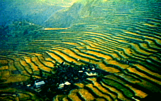 Classic Bench Terraces