Models: L-THIA, SedSpec, LDC, WHAT, NAPRA
Hydrologic Impacts of Land Use Changes and Practices
L-THIA estimates changes in recharge, runoff, and nonpoint source pollution resulting from past or proposed development.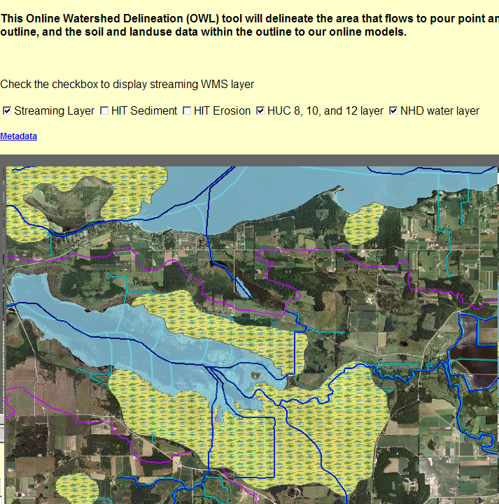
Online Models for Six States and several localities stream data to the web from our L-THIA Model.
"Green" planning approaches can be modeled with the Low Impact Development or
L-THIA LID Model.
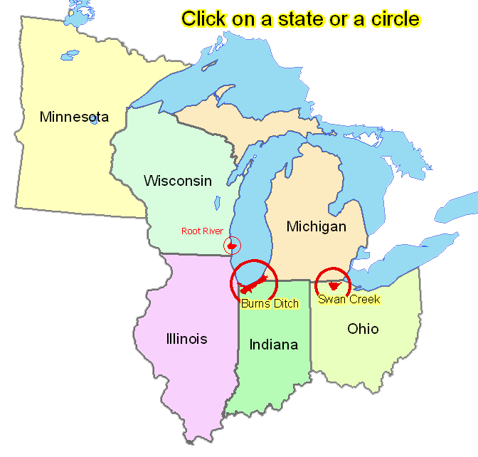
As part of the Great Lakes Tributary Modeling Program, the Chicago District of the U.S. Army Corps of Engineers, Michigan State University, and Purdue University developed a watershed management system that allows stakeholders to estimate impacts of land use change scenarios and get impervious surface estimates. With this model stakeholders can assess consequences of land use changes or applying soil conservation BMPs and non-point source pollution measures. Third, hydrologists may use a model to design a number of erosion and sediment control structures.
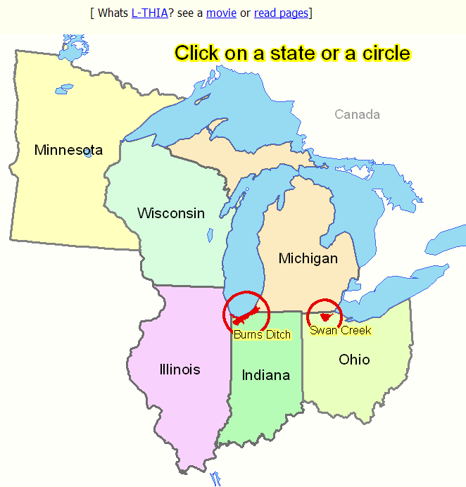
The Burns Ditch and Trail Creek Watershed Management System includes the two named watersheds which drain into Lake Michigan and areas within three northwestern counties of Indiana: Lake, Porter, and La Porte.
The Swan Creek Watershed Management System is a collaboration between Purdue University and the Institute for Water Resources of Michigan State University. The site provides tools to evaluate land cover change scenarios, estimate nutrient runoff, prioritize sub-basins by erosion and sediment loading, evaluate BMP cost benefits, explore low impact development (LID) options, and map-browsing. This subwatershed is in the Maumee River Watershed.
SedSPEC:: SedSpec is an expert system that will assist you in analyzing runoff and erosion problems on your site by determining the peak rate of runoff from the area. The analysis will provide information about different types of runoff and erosion control structures.
|
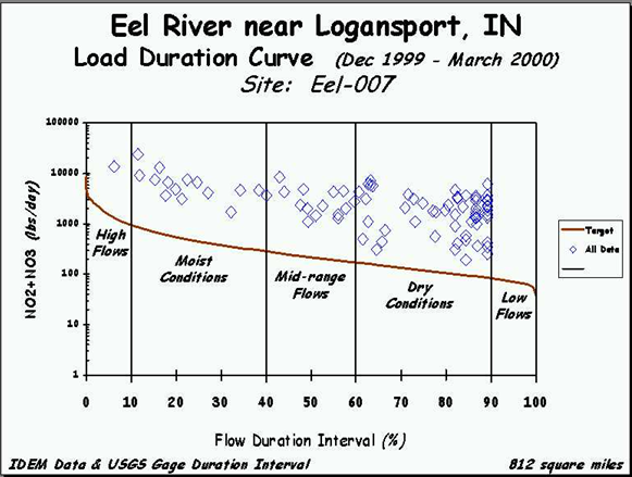
LDC:: Build Load Duration Curves from the online USGS gage data sets! The load duration curve approach provides a way to characterize water quality concentrations at different flow regimes. There is an immediate, visual display of the relationship between stream flow and loading capacity. With this model the frequency and magnitude of water quality standard exceedances, adjustable allowable loadings, and the size of load reductions are easily understood.
|
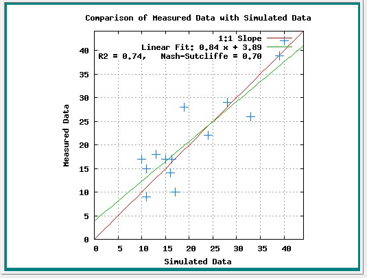
WHAT :: Web-Based Hydrograph Analysis Tool: The separation of the base flow component from a varying streamflow hydrograph is called “hydrograph analysis.” In this model, two digital filter based separation modules, the BFLOW and Eckhardt filters, were incorporated into the Web based Hydrograph Analysis Tool (WHAT) system to compute R2 and Nash-Sutcliffe coefficients to calibrate/validate the model. The (GIS) version of the WHAT system accesses and uses U.S. Geological Survey (USGS) daily streamflow data from the USGS web server. -------------------------------------------------- |
 |
------------------------------------------------- |
L-THIA™ :: available as an online Google Map (TM) interface for these six midwestern states and two local versions. This interface includes Online Watershed Delineation from a point. Simple Spreadsheet: Basic L-THIA L-THIA estimates changes in recharge, runoff, and nonpoint source pollution resulting from past or proposed development. |
|

Driftwatch™:: is a tool to help protect pesticide-sensitive crops and habitats in the Midwest. Pesticide applicators locate registered sites before they spray using a Google Maps™ interface. This is a method of facilitating voluntary communications between the pesticide applicator and the specialty crop grower to help ensure sensitive areas are protected, while encouraging appropriate pesticide application.
------------------------------------------------
NAPRA:: Pesticides have been found in surface and groundwater nationwide. Many pesticide detections can be attributed to point source contamination, but nonpoint source contamination due to agricultural practices is still a major concern.
Management decisions need to minimize the risk of loss of pesticides to the environment. Such decisions should delicately strike a balance between efficacy, economics and the environment to provide for voluntary sustainable agriculture.
The goal of the National Agricultural Pesticide Risk Analysis (NAPRA) process is to help policy-makers as well as farmers to make informed pesticide management decisions.
The NAPRA process is designed to help quantify the environmental benefits of potential management alternatives through the use of water quality simulation models combined with statistical analysis. Results are probability based and consider both the off-site movement of pesticide and its toxicity to non- target species.
The NAPRA approach was developed by the USDA Natural Resources Conservation Service (NRCS) at the Amherst, MA location. Key NRCS personnel involved in its development include Joseph Bagdon, Stephen Plotkin, Eric Hesketh, and Morgan Hugo. The NAPRA Web materials at this site were developed in cooperation with the NRCS NAPRA team.