Video
This video gives a short overview of our project. Motivation, solution, and demonstration are all explained in three minutes.
Summary
We have created a system user interface to help prevent people from getting lost while travelling together. We used paper prototypes and surveys to garner feedback from potential users of our system to guide our design process. We tested our interface by running short usability studies on fellow classmates. Our interface design is straightforward to use. This helps to minimize the frustration that happens when a person following another car loses sight of the car they were following to their destination.
Motivation
Have you ever needed to follow someone in a car to a destination that is far away, off the grid, or is otherwise difficult to get to? Have you ever lost sight of the car you were following? Maybe you got held up at a stoplight or did not see which exit they took on the freeway. If the lead car does not notice when or where they lost you, it can be difficult for them to know how far they need to backtrack, if at all, before you come back into their vision and continue on your journey. This can be solved nowadays with a simple phone call to the other car, but this takes time: many localities have banned the use of hand-held devices while driving. It is much safer anyway to pull over to dial the phone and talk than it is to drive in an unfamiliar location with your phone pressed to your ear.
Solution
Our solution is no more distracting than a GPS system or other map service one might use while driving, since the set up occurs before the wheels begin rolling and is henceforth hands-free. We implement a location sharing feature in Google Maps, which enables users to share their locations with others. In our implementation, the user can choose to be a leader or a follower. The leader decides where to go and who can follow him/her and the follower can use this information, displayed on a map, to reach the location of the leader on his/her way to the destination. Both the leader and the follower share their location on Google Maps so that they have a sense of how close or how far they are to each other. Our goal in this project was to successfully implement the "following" feature and help people successfully reach their destination. The target audience for our tool includes people who are unable to remember multitudes of directions, especially in unfamiliar locales, and who would benefit from being able to visualize not only where they are on a map, but also the person(s) they are meant to be following.
Related work
There were discovered to be existing apps, Glympse and Find My Friends, found in a summary article, that provide similar functionality to what we had chosen as our project. Each requires the user to download their app to use the location sharing service. However, our system is different from these because our implementation is meant to be used for single, temporary events that don't force the user to download an app to get started. Ours is hosted on a simple Web page for the user to access only when needed.
Design & Implementation
The development that led to the design of our system began with two independent paper prototype evaluations of the design interface. We combined the feedback garnered from these to create a single interface. Additionally, we created a short survey and gave it to a few colleagues (found in the HKN Lounge in the EE basement), who were all engineering students not taking an HCI course. The participants were able to easily set up a sample convoy via our paper prototype that was implemented in Microsoft PowerPoint and displayed on a tablet, so the actual interaction between the user and our tool was entirely via a touchscreen. For these surveys, we did not simulate movement, so the only concepts that were tested that round were the convoy set-up screens. There were a few suggestions for improvements from these participants that were taken into account for the final design.
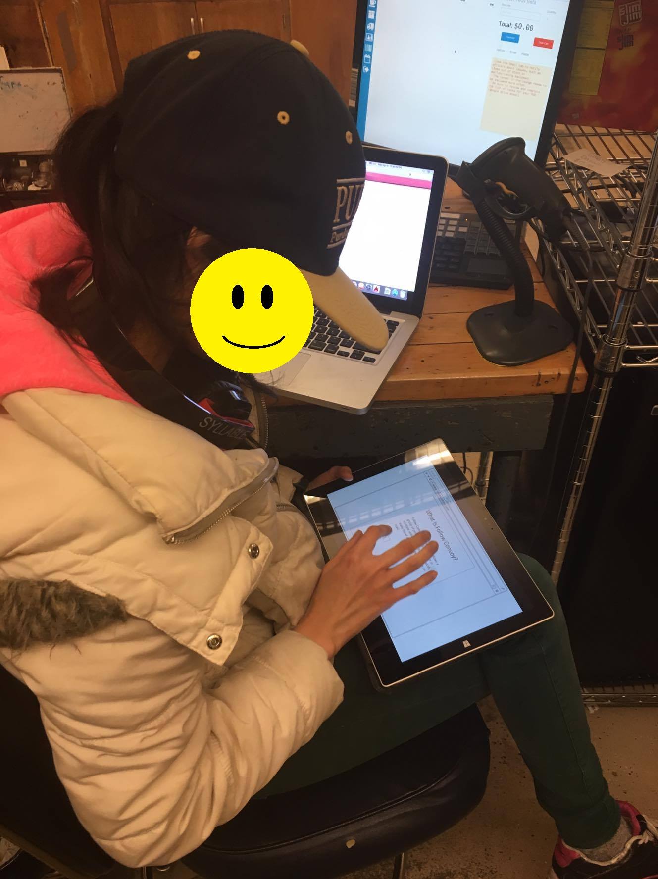
Figures 1 & 2: Participants filling out the survey and walking through the electronic paper prototype.
We are using Google Maps to show the user where they are at the current time. The user is prompted to allow the browser to know their location upon loading the web interface. We used Python, JavaScript, HTML, Tornado Web Server, and Google Maps API to implement our design. A couple of demos were used to help us get started. Geolocation is how the web browser detects the user's location, using GPS and/or WiFi location information to zone in on coordinates.
Upon entering the URL of our website, the user is presented with a screen consisting of three buttons. Clicking the first button, "Tutorial," will give the user some additional information on the tool itself. Clicking the second button, "Start a new convoy," will lead the user to the next screen, where he or she will input a convoy name and a user name. The convoy name is used to distinguish one group from another, and the user name is used to distinguish one person from another person within a single group. From the main screen again, clicking the third button, "Join a convoy," will ask the user for the convoy name (which has already been set up by either the convoy leader or someone else in the same group) and for their user name, which is used to distinguish one pinpoint on the map from another within the same convoy group. Once the convoy has been set up or joined, the user is taken to a screen that has a map on it, including both his/her own location and the locations of anyone else who has joined the same convoy as displayed by pinpoints on the map. Many different groups of people may use our tool at once to create independent convoys, no matter where they are!
Evaluation and results
We ran a test to determine if users are able to quickly set up and get going using our final design. A first-time user was asked to walk across Purdue's campus from the Electrical Engineering building to some (unknown to the study participant) location on campus.
We gave the URL of our webpage to a student and asked him to find one of the researchers, Meng-Han, who had already walked to some unknown location on Purdue's campus. The only information the participant was given was the URL of the web interface and the name of the convoy to join to find the researcher's location. There was no communication between the participant and Meng-Han while the participant was walking to find Meng-Han. The other researcher, Sylvia, followed the participant to gather data on the participant. The participant was able to determine the location of Meng-Han as soon as he logged in to the convoy and was thus able to navigate his way to rendezvous with him. Our interface helped the participant to stay on track to reach the destination by seeing the current location of Meng-Han on the map relative to his (the participant's) own. We expected that the participant would be able to understand the map and travel successfully to the destination, which turned out to be a valid expectation. We ran this test with two other participants (one at a time), with similar results.
Learnability and efficiency of our system are high, as shown by this test case. Memorability was not measured since the participant was a first-timer. However, the ease with which the participant was able to complete his task indicates that since learnability is high, memorability would also be high. There were few errors made, and those that were made were quickly corrected with little adverse consequence. The user indicated that he was quite satisfied with the simple and clean design of the system. With more studies we could better quantify and qualify these and other metrics.
Conclusions
Our interface design is straightforward to use. This helps minimize the frustration experienced when a person following another person in a car, or in the test case detailed above, on foot, loses sight of the person they were following to their destination and needs to have a way to quickly be able to reach that other person's location. The time saved by using our service, instead of using the old method of stopping, pulling over, and calling the other person to rendezvous, can instead be used spending more time with company at the group's destination!
Future Works
For future work, we will include more security features and the ability to "quick start" a convoy by, after the leader sets up the convoy, sending the link via email or text message to fellow convoy members so that all they have to do is click on the sent link to join the convoy. In addition, we would run more tests on participants with varying backgrounds.
Acknowledgements
- http://mypersonalsoft.blogspot.com/2012/02/simulating-moving-targets-in-google.html
- https://www.youtube.com/watch?v=qYFkPFtfgdI
- http://www.tornadoweb.org/en/stable/
- https://developers.google.com/maps/
- http://www.jpablo128.com/multi-room-websockets-server-with-tornado-i-basic-chat-server